ملف:Comanche County Oklahoma Incorporated areas highlighting Lawton.svg

حجم معاينة PNG لذلك الملف ذي الامتداد SVG: 582 × 599 بكسل. الأبعاد التانيه: 233 × 240 بكسل | 466 × 480 بكسل | 746 × 768 بكسل | 995 × 1,024 بكسل | 1,990 × 2,048 بكسل.
الصوره الاصليه (ملف SVG، اساسا 582 × 599 بكسل، حجم الملف: 801 كيلوبايت)
الخلاصة
| وصف |
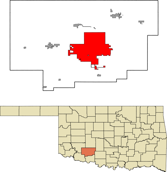
English: A map highlighting the city of Lawton in Comanche County in the US state of Oklahoma. Data provided from geo.ou.edu Based on similar maps from Ixnayonthetimmay |
| تاريخ | |
| مصدر | عمل شخصى |
| مؤلف | Crimsonedge34 |
| SVG منشأ الملف |
الترخيص
أنا، صاحب حقوق التأليف والنشر لهذا العمل، أنشر هذا العمل تحت الرخصة التالية:
| هذا الملف متوفر تحت ترخيص المشاع الإبداعي CC0 1.0 الحقوق العامة. | |
| لقد وَضَعَ صاحب حقوق التَّأليف والنَّشر هذا العملَ في النَّطاق العامّ من خلال تنازُلِه عن حقوق العمل كُلِّها في أنحاء العالم جميعها تحت قانون حقوق التَّأليف والنَّشر، ويشمل ذلك الحقوق المُتَّصِلة بها والمُجاورة لها برمتها بما يتوافق مع ما يُحدده القانون. يمكنك نسخ وتعديل وتوزيع وإعادة إِنتاج العمل، بما في ذلك لأغراضٍ تجاريَّةٍ، دون حاجةٍ لطلب مُوافَقة صاحب حقوق العمل.
|
تاريخ الفايل
اضغط على الساعه/التاريخ علشان تشوف الفايل زى ما كان فى الوقت ده.
| الساعه / التاريخ | صورة صغيرة | ابعاد | يوزر | تعليق | |
|---|---|---|---|---|---|
| دلوقتي | 07:47، 13 اكتوبر 2011 | | 582 × 599 (801 كيلوبايت) | Crimsonedge34 | Margins |
| 06:49، 13 اكتوبر 2011 |  | 692 × 646 (727 كيلوبايت) | Crimsonedge34 | Would help if I uploaded the correct map. | |
| 06:48، 13 اكتوبر 2011 |  | 1,052 × 744 (42 كيلوبايت) | Crimsonedge34 | {{Information |Description ={{en|1=A map highlighting the city of Lawton in Comanche County in the US state of Oklahoma. Based on similar maps from Ixnayonthetimmay}} |Source ={{own}} |Author =[[User:Crimso |
استخدام الفايل
ال1 صفحة دى فيها وصله للفايل ده:
استخدام الملف العام
الويكيات التانيه دى بتستخدم الفايل ده:
- الاستخدام ف ar.wikipedia.org
- الاستخدام ف azb.wikipedia.org
- الاستخدام ف br.wikipedia.org
- الاستخدام ف ca.wikipedia.org
- الاستخدام ف en.wikipedia.org
- الاستخدام ف eu.wikipedia.org
- الاستخدام ف fa.wikipedia.org
- الاستخدام ف fi.wikipedia.org
- الاستخدام ف fr.wikipedia.org
- الاستخدام ف ga.wikipedia.org
- الاستخدام ف gd.wikipedia.org
- الاستخدام ف ht.wikipedia.org
- الاستخدام ف hu.wikipedia.org
- الاستخدام ف ia.wikipedia.org
- الاستخدام ف id.wikipedia.org
- الاستخدام ف kw.wikipedia.org
- الاستخدام ف no.wikipedia.org
- الاستخدام ف pt.wikipedia.org
- الاستخدام ف sh.wikipedia.org
- الاستخدام ف simple.wikipedia.org
- الاستخدام ف sr.wikipedia.org
- الاستخدام ف sv.wikipedia.org
- الاستخدام ف tr.wikipedia.org
- الاستخدام ف tt.wikipedia.org
- الاستخدام ف ur.wikipedia.org
- الاستخدام ف vo.wikipedia.org
- الاستخدام ف www.wikidata.org
- الاستخدام ف zh.wikipedia.org