ملف:Crookston Commercial Historic District.jpg

حجم البروفه دى: 757 × 599 بكسل. الأبعاد التانيه: 303 × 240 بكسل | 606 × 480 بكسل | 956 × 757 بكسل.
الصوره الاصليه (956 × 757 بكسل حجم الفايل: 84 كيلوبايت، نوع MIME: image/jpeg)
|
هذه الصُّورة لمَوقعٍ أَو بناءٍ مُصنفٌ حالياً في السِّجل الوطنيُّ للأَماكن التَّاريخيَّة في الولايات المُتحدة الأَمريكيَّة تحت المُعرِّف 84002709. |
| وصف |
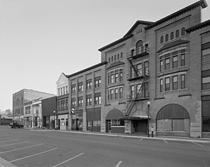
English: Buildings in the Crookston Commercial Historic District in central Crookston, Polk County, Minnesota, United States. The district reflects the city's early period of growth, which was prompted by agriculture and the railroad industry. It remains a large, and mostly intact, concentration of late nineteenth- and early twentieth-century commercial structures and is listed on the National Register of Historic Places. |
|||||
| تاريخ | تاريخ مش معروف | |||||
| مصدر | Library of Congress Prints and Photographs Division, Historic American Buildings Survey: MINN,60-CROK,1-6 | |||||
| مؤلف | مجهول | |||||
| سماح (إعادة استخدام الملف ده) |
|

| موقع الكائن | | هذه وغيرها من الصور في مواقعها على: خريطة الشارع المفتوحة |
|---|

|
هذه الصُّورة مُوفَّرة مِن قِبل مكتبة الكونغرس قسم المطبوعات والصُّور تحت الهويَّة الرَّقميَّة hhh.mn0444.
لا يُشير هذه الوَسم إلى حالة حقوق التَّأليف والنَّشر الخاصَّة بالعمل المُرفَق؛ لا يزال وَسم حقوق التَّأليف والنَّشر مَطلُوباً، راجع كومنز:ترخيص لمزيدٍ من المعلومات.
|
تاريخ الفايل
اضغط على الساعه/التاريخ علشان تشوف الفايل زى ما كان فى الوقت ده.
| الساعه / التاريخ | صورة صغيرة | ابعاد | يوزر | تعليق | |
|---|---|---|---|---|---|
| دلوقتي | 14:07، 31 يناير 2009 | | 956 × 757 (84 كيلوبايت) | Cropbot | upload cropped version, operated by User:Finavon. Summary: border cropped |
| 14:35، 29 يناير 2009 |  | 1,024 × 818 (96 كيلوبايت) | Nyttend | {{Information |Description=Photograph from the {{w|Historic American Buildings Survey}} of buildings in the {{w|Crookston Commercial Historic District}}, an area listed on the {{w|National Register of Historic Places}}. The district is located in central |
استخدام الفايل
ال1 صفحة دى فيها وصله للفايل ده:
استخدام الملف العام
الويكيات التانيه دى بتستخدم الفايل ده:
- الاستخدام ف ar.wikipedia.org
- الاستخدام ف azb.wikipedia.org
- الاستخدام ف be.wikipedia.org
- الاستخدام ف ca.wikipedia.org
- الاستخدام ف ceb.wikipedia.org
- الاستخدام ف ce.wikipedia.org
- الاستخدام ف dag.wikipedia.org
- الاستخدام ف de.wikipedia.org
- الاستخدام ف en.wikipedia.org
- الاستخدام ف en.wikivoyage.org
- الاستخدام ف es.wikipedia.org
- الاستخدام ف eu.wikipedia.org
- الاستخدام ف fa.wikipedia.org
- الاستخدام ف fr.wikipedia.org
- الاستخدام ف ht.wikipedia.org
- الاستخدام ف hu.wikipedia.org
- الاستخدام ف ia.wikipedia.org
- الاستخدام ف ko.wikipedia.org
- الاستخدام ف ky.wikipedia.org
- الاستخدام ف lld.wikipedia.org
- الاستخدام ف pt.wikipedia.org
- الاستخدام ف ru.wikipedia.org
- الاستخدام ف sh.wikipedia.org
- الاستخدام ف sr.wikipedia.org
- الاستخدام ف tr.wikipedia.org
- الاستخدام ف tt.wikipedia.org
- الاستخدام ف uk.wikipedia.org
- الاستخدام ف ur.wikipedia.org
- الاستخدام ف uz.wikipedia.org
- الاستخدام ف vi.wikipedia.org
- الاستخدام ف www.wikidata.org
- الاستخدام ف zh-min-nan.wikipedia.org