ملف:Spread of Christianity to AD 600 - Atlas of World History.png

حجم البروفه دى: 800 × 592 بكسل. الأبعاد التانيه: 320 × 237 بكسل | 640 × 474 بكسل | 1,024 × 758 بكسل | 1,280 × 948 بكسل | 2,187 × 1,619 بكسل.
الصوره الاصليه (2,187 × 1,619 بكسل حجم الفايل: 227 كيلوبايت، نوع MIME: image/png)
الخلاصة
| وصف |
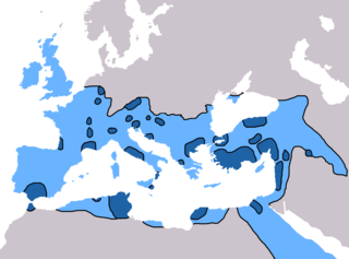
English: Map of the spread of Christianity in Europe, Southwest Asia and North Africa to the year AD 600.
"redominantly Christian by AD 325" zone coloured in dark blue, "Predominantly Christian by AD 600" coloured in light blue.
Predominantly Christian by AD 325
Predominantly Christian by AD 600
Magyar: A kereszténység elterjedése:
Kr. u. 325-ig
325 és 600 között
Information obtained from Patrick O'Brien , ed. (2003) Atlas of World History، تصنيف:نيويورك: Oxford University Press، pp. 44−5 0-19-521921-X Map created and uploaded in the English Wikipedia by Geuiwogbil. Base map: "File:BlankMap-Europe-v3.png" |
| تاريخ | 27 مايو 2009 (تاريخ الرفع الأصيل) |
| مصدر | Transferred from en.wikipedia to Commons by QuartierLatin1968 using CommonsHelper. |
| مؤلف | Geuiwogbil في ويكيبيديا الإنجليزية |

|
هذه religion map الصورة / الصورتان باستعمال رسومات متجهية ملفات رسوميات شعاعية.
It is recommended to name the SVG file "Spread of Christianity to AD 600 - Atlas of World History.svg" - then the template Vector version available (or Vva) does not need the new image name parameter.
|
الترخيص
Geuiwogbil من en.wikipedia.org، صاحب حقوق التأليف والنشر لهذا العمل، أنشر هذا العمل تحت الرخصة التالية:
| الملف ده مترخص حسب رخصة المشاع الإبداعى نسبة المصنف للى مألفه - المشاركة بالمثل 3.0 العامه Subject to disclaimers. | ||
| نسبه ل: Geuiwogbil من en.wikipedia.org | ||
| ||
| تمت إضافة علامة الترخيص لهذا الملف كجزء من رخصة جنو للوثائق الحرة تحديث الترخيص. |

|
يسمح بنسخ و توزيع و / أو تعديل الوثيقه دى تحت شروط رخصة جنو للوثائق الحره، الإصدار 1.2 أو أى إصدار تنشره مؤسسة البرمجيات الحره؛ بدون أقسام ثابته و بدون نصوص أغلفه أماميه و بدون نصوص أغلفه خلفيه. نسخه من الرخصه متضمنه ف قسم اسمه GNU Free Documentation License. Subject to disclaimers. |
سجلُّ الرَّفع الأصيل
The original description page was here. All following user names refer to en.wikipedia.
- 2009-05-27 19:20 Carlaude 2187×1619× (232587 bytes) Cutting out unused areas of the map
- 2006-09-09 02:34 Geuiwogbil 2285×2181× (248280 bytes) Blue provides us with a better constrast.
- 2006-09-04 05:10 Geuiwogbil 2285×2181× (254524 bytes)
- 2006-09-04 05:08 Geuiwogbil 2285×2181× (116034 bytes) Map of the spread of Christianity in Europe, Southwest Asia and North Africa to the year 600 AD. Base map "BlankMap-Europe-v.3." Spread of Christianity to AD 325 coloured in orange, to 600 coloured in yellow. Information obtained from {{cite book |editor=
تاريخ الفايل
اضغط على الساعه/التاريخ علشان تشوف الفايل زى ما كان فى الوقت ده.
| الساعه / التاريخ | صورة صغيرة | ابعاد | يوزر | تعليق | |
|---|---|---|---|---|---|
| دلوقتي | 17:31، 3 يونيه 2022 | | 2,187 × 1,619 (227 كيلوبايت) | Veverve | Reverted to version as of 10:19, 4 July 2021 (UTC) please bring a map source to counter this claim that only part of Armenia etc. were partially christianised |
| 17:08، 3 يونيه 2022 |  | 2,187 × 1,619 (245 كيلوبايت) | Rs4815 | Reverted to version as of 09:58, 24 February 2013 (UTC) You can't just ignore the fact that the "sourced version of the map" has a blunder. By the year 325, the Armenian kingdom had already been converted to Christianity | |
| 10:19، 4 يوليه 2021 |  | 2,187 × 1,619 (227 كيلوبايت) | Veverve | Reverted to version as of 12:31, 9 November 2009 (UTC) revert to what is an actually sourced version of the map | |
| 06:34، 23 مايو 2018 |  | 2,187 × 1,619 (213 كيلوبايت) | Inowen | Add labels for Europe, Africa, and Middle East using Inkscape to import previous and overlay text in svg. | |
| 09:58، 24 فبراير 2013 |  | 2,187 × 1,619 (245 كيلوبايت) | Prince of Nothing05 | Kingdom of Armenia, Iberia and Caucasian Albania had already made Christianity official religion. | |
| 12:31، 9 نوفمبر 2009 |  | 2,187 × 1,619 (227 كيلوبايت) | QuartierLatin1968 | {{Information |Description={{en|Map of the spread of Christianity in Europe, Southwest Asia and North Africa to the year 600 AD. Base map "BlankMap-Europe-v.3." Spread of Christianity to AD 325 coloured in light blue, to 600 coloured in dark blue. Informa |
استخدام الفايل
ال1 صفحة دى فيها وصله للفايل ده:
استخدام الملف العام
الويكيات التانيه دى بتستخدم الفايل ده:
- الاستخدام ف ar.wikipedia.org
- الاستخدام ف be.wikipedia.org
- الاستخدام ف bg.wikipedia.org
- الاستخدام ف ca.wikipedia.org
- الاستخدام ف cs.wikipedia.org
- الاستخدام ف de.wikipedia.org
- الاستخدام ف el.wikipedia.org
- الاستخدام ف en.wikipedia.org
- Christendom
- Christian Church
- Christianity in Africa
- Talk:Christian Church/Archive 1
- Christianity in the Middle East
- Spread of Christianity
- Multiculturalism and Christianity
- Western world
- Christianity in the ante-Nicene period
- Christianity in the 4th century
- Christianity in the 5th century
- Christianity in the 6th century
- Christianity in the 7th century
- Christianity in late antiquity
- Christianity as the Roman state religion
- Roman people
- User:Falcaorib
- الاستخدام ف en.wikibooks.org
- الاستخدام ف en.wikiquote.org
- الاستخدام ف eo.wikipedia.org
- الاستخدام ف es.wikipedia.org
اعرض استخدام عام اكتر للملف ده.