نورثهامبتون
نورثهامبتون هىًا تاون ف انجلترا ف المملكه المتحده و هيا مركز إدارة نورثهامبتونشير
نورثهامپتون | |
|---|---|
 | |
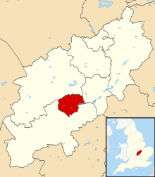
 Northampton shown within Northamptonshire | |
| Sovereign state | United Kingdom |
| Constituent country | England |
| Region | East Midlands |
| Ceremonial county | Northamptonshire |
| Admin HQ | Northampton Guildhall |
| Town charter | 1189 |
| Incorporated | 1835 |
| Government | |
| • Type | Non-metropolitan district |
| • Governing body | Northampton Borough Council |
| • Leader | David Mackintosh (Con) |
| • Mayor | Les Marriott (Lab) |
| • MPs | Brian Binley (Con) Michael Ellis (Con) Andrea Leadsom (Con) |
| Area | |
| • Total | 31.18 sq mi (80.76 km2) |
| Population (2008 est.) | |
| • Total | 212,500 (Ranked 73rd) |
| • Density | 6,810/sq mi (2,631/km2) |
| • Ethnicity | 84.5% White 6.4% South Asian 5.1% Black 3.2% Mixed Race 0.3% Arab 0.5% Other |
| Demonym | Northamptonian |
| Time zone | UTC0 (GMT) |
| • Summer (DST) | UTC+1 (BST) |
| Postcode area | |
| Area code | 01604 |
| ISO 3166-2 | GB-NTH |
| ONS code | 34UF (ONS) E07000154 (GSS) |
| NUTS 3 | UKF24 |
| Website | northampton.gov.uk |
الاسم تعديل
اول تسجيل مكتوب معروف لاسم نورثهامبتون كان سنة 914 تحت اسم هام تيون [1] [2][3][2][3] و بعدين اتضاف للاسم كلمة نورث عشان تمييزها من اماكن تانيه اسمها هامبتون زى ما حصل مع ساوثهامبتون. اسم نورثهامبتون إتعرف أكتر و استعمل ف المكاتبات الرسمى ف القرن السبعتاشر[1][4]
مصادر تعديل
- ↑ أ ب The borough of Northampton - Introduction | A History of the County of Northampton: Volume 3 (pp. 1-26). British-history.ac.uk (1913-09-23). Retrieved on 2013-07-17.
- ↑ أ ب Leleux (1984), p. 54.
- ↑ أ ب Harrison, Chaz (2009-08-11). "Ever wondered what lies beneath?". BBC News. Retrieved 2010-08-30.
- ↑ "Charles II, 1675 - An Act for the better and more easy rebuilding the Towne of Northampton. | Statutes of the Realm: volume 5 (pp. 798-801)". British-history.ac.uk. 2003-06-22. Retrieved 2013-08-29.