ملف:1730 Seutter Map of Turkey (Ottoman Empire), Persia and Arabia - Geographicus - MagniTurcarum-seutter-1740.jpg

حجم البروفه دى: 691 × 600 بكسل. الأبعاد التانيه: 277 × 240 بكسل | 553 × 480 بكسل | 885 × 768 بكسل | 1,180 × 1,024 بكسل | 2,360 × 2,048 بكسل | 5,000 × 4,339 بكسل.
الصوره الاصليه (5,000 × 4,339 بكسل حجم الفايل: 5.27 ميجابايت، نوع MIME: image/jpeg)
| الفنان |
|
|||||||||||||||||||||||
| العنوان |
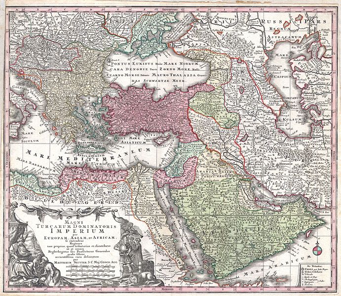
MAGNI TURCARUM DOMINATORIS IMPERIUM per EUROPAM, ASIAM ET AFRICAM, se extendens Regiones tam proprias, quan tributarias et clientelares ut et omnes Beglerbegatus sive Praefecturas Generales oculis sistens accuratissima cura delineatum per MATTHAEUM SEUTTER, S.C. Maj. Geogr. Aug. |
|||||||||||||||||||||||
| وصف |
English: A spectacular c. 1730 map of the Ottoman Empire, including Greece, Turkey, Persia, Egypt and Arabia, by the important Augsburg map publisher Gerog Matthaus Seutter. Depicts from Italy eastward to the Caspian Sea, which is depicted in its entirety. Includes Crimea and the Caucuses: Georgia, Circassia and Armenia. Extends south to include all of Arabia and the northern tip of the Horn of Africa. Generally accurate with a few cartographic anomalies. The Dead Sea is over-large and misshapen. A large and nonexistent lake appears just west of the Nile Delta. In the lower left hand quadrant there is a large decorative title cartouche attributed to the Augsburg silversmith Abraham Drentwet. Depicts the ottoman Emperor gloriously robed with and enthroned. On the ground before him two men bow and offer hum treasures. The images on the right of the title offer a more allegorical references and include an European holding a globe, a lion, the Rod of Asclepius, a Medusa head shield and s spear. Angels with trumpets look on from above. A map key appears in the lower right quadrant. Cartographically similar to Visscher's 1690 map of the same area. This is a rather unusual state of the map and one of the few examples wherein S.G. Maj Geogr. Aug follows Seutter's name in the title cartouche. The only comparable example we have found is in the British Museum. |
|||||||||||||||||||||||
| تاريخ | قرابة 1730(undated) | |||||||||||||||||||||||
| الأبعاد | ارتفاع: 20 إنش (50.8 سم)؛ العرض: 23 إنش (58.4 سم) | |||||||||||||||||||||||
| رقم التصنيف |
وصلة موقع جيوغرافيكوس: MagniTurcarum-seutter-1740 |
|||||||||||||||||||||||
| المصدر/المصور |
Atlas Novus. Matthaeso Seutter. (1730)
|
|||||||||||||||||||||||
| سماح (إعادة استخدام الملف ده) |
|
|||||||||||||||||||||||

,_Persia_and_Arabia_-_Geographicus_-_MagniTurcarum-seutter-1740.jpg)
تاريخ الفايل
اضغط على الساعه/التاريخ علشان تشوف الفايل زى ما كان فى الوقت ده.
| الساعه / التاريخ | صورة صغيرة | ابعاد | يوزر | تعليق | |
|---|---|---|---|---|---|
| دلوقتي | 16:08، 16 مارس 2011 | | 5,000 × 4,339 (5.27 ميجابايت) | BotMultichill | {{subst:User:Multichill/Geographicus |link=http://www.geographicus.com/P/AntiqueMap/MagniTurcarum-seutter-1740 |product_name=1730 Seutter Map of Turkey (Ottoman Empire), Persia and Arabia |map_title=MAGNI TURCARUM DOMINATORIS IMPERIUM per EUROPAM, ASIAM E |
استخدام الفايل
ال1 صفحة دى فيها وصله للفايل ده:
استخدام الملف العام
الويكيات التانيه دى بتستخدم الفايل ده:
- الاستخدام ف ar.wikipedia.org
- الاستخدام ف azb.wikipedia.org
- الاستخدام ف az.wikipedia.org
- الاستخدام ف bn.wikipedia.org
- الاستخدام ف ckb.wikipedia.org
- الاستخدام ف en.wikipedia.org
- الاستخدام ف fa.wikipedia.org
- الاستخدام ف fr.wikipedia.org
- الاستخدام ف it.wikipedia.org
- الاستخدام ف ko.wikipedia.org
- الاستخدام ف ms.wikipedia.org
- الاستخدام ف pnb.wikipedia.org
- الاستخدام ف ru.wikipedia.org
- الاستخدام ف sl.wikipedia.org
- الاستخدام ف sq.wikipedia.org
- الاستخدام ف tr.wikipedia.org
- الاستخدام ف uk.wikipedia.org
- الاستخدام ف ur.wikipedia.org
- الاستخدام ف zh.wikipedia.org
,_Persia_and_Arabia_-_Geographicus_-_MagniTurcarum-seutter-1740.jpg)