ملف:Abbasid Caliphate 891-892.png

حجم البروفه دى: 800 × 382 بكسل. الأبعاد التانيه: 320 × 153 بكسل | 640 × 306 بكسل | 1,024 × 490 بكسل | 1,280 × 612 بكسل | 3,054 × 1,460 بكسل.
الصوره الاصليه (3,054 × 1,460 بكسل حجم الفايل: 1.44 ميجابايت، نوع MIME: image/png)
الخلاصة
| وصف |
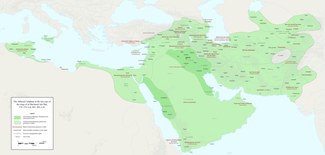
English: Map of the Abbasid Caliphate at the end of the reign of al-Mu'tamid in 891-892. Dark green denotes provinces under the effective control of the central government; light green denotes provinces under the control of autonomous governors or rebels.
The core Abbasid territories include Shahrazur, Darabadh, al-Samaghan, Hulwan, Masabadhan, Mihrijanqadhaq, the Euphrates districts, and Qarqisiyya (al-Tabari v. 37, p. 98; Bianquis p. 96). Map originally created as an .SVG file in Inkscape and converted to .PNG for size reasons. Background topography taken from DEMIS Mapserver, which are public domain. Works Cited:
|
| تاريخ | |
| مصدر | عمل شخصى |
| مؤلف | Ro4444 |
| إصدارات أخرى |
 |
الترخيص
أنا، صاحب حقوق التأليف والنشر لهذا العمل، أنشر هذا العمل تحت الرخصة التالية:
هذا الملفُّ مُرخَّصٌ برخصة المشاع الإبداعي الدَّوليَّة المُلزِمة بنسب العمل إلى مُؤَلِّفه وبترخيص المُشتقَّات بالمثل 4.0.
- إنت حر:
- فى المشاركه – علشان نسخ و توزيع و بث العمل
- إنك تمزج – فى تكييف العمل
- بالشروط دى:
- نسبه ل – لازم يتنسب العمل للى مألفه بشكل مناسب و توفير رابط للرخصه وتحديد اذا حصلت تغييرات. ممكن ده يتعمل بأى طريقه معقوله، لكن مش بطريقه تشير ان مانح الرخصه بيوافقك على الاستعمال.
- مشاركه زي – لو عدت إنتاج المواد أو غيرت فيها، لازم تنشر مساهماتك اللى جايه من الأصل تحت ترخيص الأصل نفسه أو تحت ترخيص متوافق معاه.
تاريخ الفايل
اضغط على الساعه/التاريخ علشان تشوف الفايل زى ما كان فى الوقت ده.
| الساعه / التاريخ | صورة صغيرة | ابعاد | يوزر | تعليق | |
|---|---|---|---|---|---|
| دلوقتي | 23:18، 3 ديسمبر 2017 | | 3,054 × 1,460 (1.44 ميجابايت) | Ro4444 | Further color corrections |
| 22:50، 3 ديسمبر 2017 |  | 3,054 × 1,460 (1.44 ميجابايت) | Ro4444 | Color correction | |
| 21:11، 3 ديسمبر 2017 |  | 3,054 × 1,460 (1.44 ميجابايت) | Ro4444 | User created page with UploadWizard |
استخدام الفايل
مافيش صفحات بتوصل للفايل ده.
استخدام الملف العام
الويكيات التانيه دى بتستخدم الفايل ده:
- الاستخدام ف ar.wikipedia.org
- الاستخدام ف de.wikiversity.org
- الاستخدام ف en.wikipedia.org
- الاستخدام ف en.wikibooks.org
- الاستخدام ف et.wikipedia.org
- الاستخدام ف fa.wikipedia.org
- الاستخدام ف hy.wikipedia.org
- الاستخدام ف id.wikipedia.org
- الاستخدام ف ja.wikipedia.org
- الاستخدام ف no.wikipedia.org
- الاستخدام ف pt.wikipedia.org
- الاستخدام ف sco.wikipedia.org
- الاستخدام ف uk.wikipedia.org
- الاستخدام ف uz.wikipedia.org
- الاستخدام ف zh.wikipedia.org