ملف:Anatolia1300.png
مافيش ريزوليوشن اعلى متوفر.
Anatolia1300.png (535 × 330 بكسل حجم الفايل: 81 كيلوبايت، نوع MIME: image/png)
الخلاصة
| وصف |
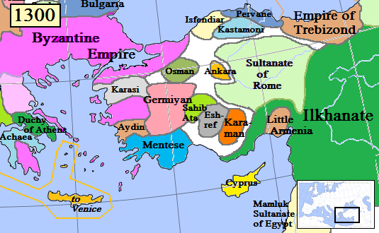
English: Map of the Anatolia region in AD 1300.
(Partially based on Euratlas map of Europe, 1300.) |
| تاريخ | |
| مصدر | عمل شخصى |
| مؤلف | Gabagool |
| إصدارات أخرى |
.png)
الترخيص
أنا، صاحب حقوق التأليف والنشر لهذا العمل، أنشر هذا العمل تحت الرخصة التالية:
هذا الملف مُرخص تحت رخصة المشاع المبدع نسبة المصنف إلى مؤلفه 3.0 العامة
- إنت حر:
- فى المشاركه – علشان نسخ و توزيع و بث العمل
- إنك تمزج – فى تكييف العمل
- بالشروط دى:
- نسبه ل – لازم يتنسب العمل للى مألفه بشكل مناسب و توفير رابط للرخصه وتحديد اذا حصلت تغييرات. ممكن ده يتعمل بأى طريقه معقوله، لكن مش بطريقه تشير ان مانح الرخصه بيوافقك على الاستعمال.
تاريخ الفايل
اضغط على الساعه/التاريخ علشان تشوف الفايل زى ما كان فى الوقت ده.
| الساعه / التاريخ | صورة صغيرة | ابعاد | يوزر | تعليق | |
|---|---|---|---|---|---|
| دلوقتي | 16:46، 20 يناير 2017 | | 535 × 330 (81 كيلوبايت) | Cplakidas | fixing Dodecanese: Menteshe never controlled the offshore islands; they remained Byzantine until the Hospitallers or Genoese of Chios took them. |
| 22:26، 17 ابريل 2009 |  | 535 × 330 (64 كيلوبايت) | Gabagool | Byzantine color lighter. New Armenia -> Little Armenia | |
| 19:12، 2 ابريل 2009 |  | 535 × 330 (64 كيلوبايت) | Gabagool | added mamluks | |
| 16:36، 31 مارس 2009 |  | 535 × 330 (63 كيلوبايت) | Gabagool | {{Information |Description={{en|1=Map of the Anatolia region in AD 1300. (Partially based on Euratlas map of Europe, 1300.)}} |Source=Own work by uploader |Author=Gabagool |Date=2009-03-31 |Permission= |other_versions= }} <!--{{ImageUp |
استخدام الفايل
ال1 صفحة دى فيها وصله للفايل ده:
استخدام الملف العام
الويكيات التانيه دى بتستخدم الفايل ده:
- الاستخدام ف als.wikipedia.org
- الاستخدام ف ar.wikipedia.org
- الاستخدام ف azb.wikipedia.org
- الاستخدام ف ba.wikipedia.org
- الاستخدام ف bg.wikipedia.org
- الاستخدام ف bn.wikipedia.org
- الاستخدام ف ca.wikipedia.org
- الاستخدام ف cs.wikipedia.org
- الاستخدام ف de.wikipedia.org
- الاستخدام ف el.wikipedia.org
- الاستخدام ف en.wikipedia.org
اعرض استخدام عام اكتر للملف ده.