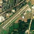
ملف:Anniston Metropolitan Airport.jpg

حجم البروفه دى: 600 × 600 بكسل. الأبعاد التانيه: 240 × 240 بكسل | 480 × 480 بكسل | 768 × 768 بكسل | 1,024 × 1,024 بكسل | 2,110 × 2,110 بكسل.
الصوره الاصليه (2,110 × 2,110 بكسل حجم الفايل: 1.39 ميجابايت، نوع MIME: image/jpeg)
تاريخ الفايل
اضغط على الساعه/التاريخ علشان تشوف الفايل زى ما كان فى الوقت ده.
| الساعه / التاريخ | صورة صغيرة | ابعاد | يوزر | تعليق | |
|---|---|---|---|---|---|
| دلوقتي | 05:22، 12 يونيه 2009 |  | 2,110 × 2,110 (1.39 ميجابايت) | AuburnPilot | == Summary == {{Information |Description=Satellite image of Anniston Metropolitan Airport in Anniston , Alabama USA on 15 June 2006 |Source=United States Geological Survey (National Agriculture Imagery Program (NAIP) |
استخدام الفايل
ال1 صفحة دى فيها وصله للفايل ده:
استخدام الملف العام
الويكيات التانيه دى بتستخدم الفايل ده:
- الاستخدام ف ceb.wikipedia.org
- الاستخدام ف en.wikipedia.org
- الاستخدام ف fa.wikipedia.org
- الاستخدام ف ro.wikipedia.org
- الاستخدام ف ru.wikipedia.org
- الاستخدام ف tg.wikipedia.org
- الاستخدام ف uk.wikipedia.org
- الاستخدام ف ur.wikipedia.org
- الاستخدام ف www.wikidata.org

