ملف:Arunachal Pradesh locator map.svg

حجم معاينة PNG لذلك الملف ذي الامتداد SVG: 734 × 600 بكسل. الأبعاد التانيه: 294 × 240 بكسل | 587 × 480 بكسل | 940 × 768 بكسل | 1,253 × 1,024 بكسل | 2,506 × 2,048 بكسل | 2,393 × 1,956 بكسل.
الصوره الاصليه (ملف SVG، اساسا 2,393 × 1,956 بكسل، حجم الملف: 263 كيلوبايت)
| العنوان |
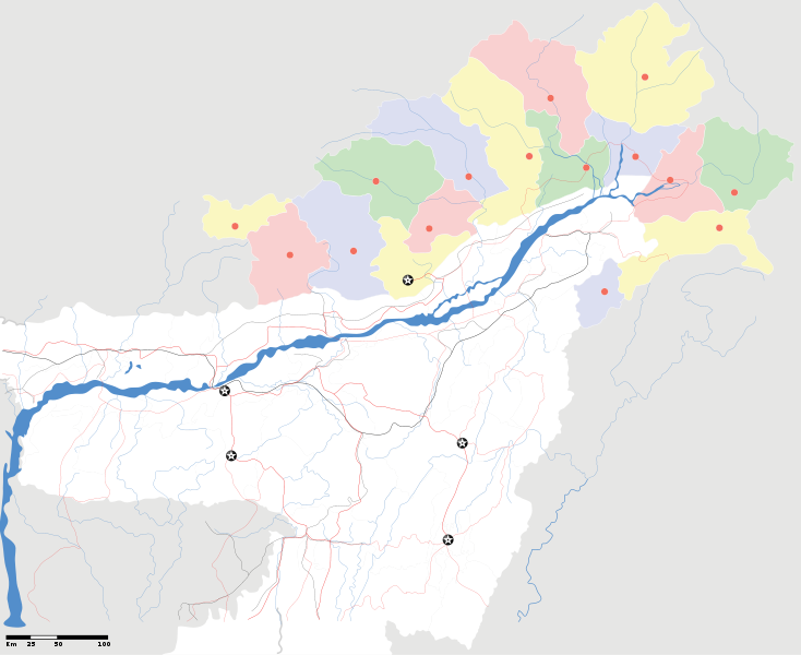
Arunachal Pradesh locator Map. Coordinates: top=29.49, bottom=23.74, left=89.61, right=97.52. |
||
| الوصف |
Map of w:Arunachal Pradesh with road and rail lines |
||
| تاريخ | |||
| مصدر |
عمل شخصى |
||
| الصانع |
|
||
| سماح (إعادة استخدام الملف ده) |
أنا، صاحب حقوق التأليف والنشر لهذا العمل، أنشر هذا العمل تحت الرخصة التالية: الملف ده مترخص حسب رخصة المشاع الإبداعى نسبة المصنف للى مألفه - المشاركة بالمثل 3.0 العامه
|
||
| Geotemporal data | |||
| تاريخ التمثيل | النصف الثاني من القرن 20 و القرن 21 | ||
| Georeferencing | If inappropriate please set warp_status = skip to hide. | ||
| Archival data | |||
| ملاحظات | Part of WikiProject India Maps | ||
derivative works
Derivative works of this file: India Arunachal Pradesh location map.svg
تاريخ الفايل
اضغط على الساعه/التاريخ علشان تشوف الفايل زى ما كان فى الوقت ده.
| الساعه / التاريخ | صورة صغيرة | ابعاد | يوزر | تعليق | |
|---|---|---|---|---|---|
| دلوقتي | 19:04، 16 ابريل 2007 | | 2,393 × 1,956 (263 كيلوبايت) | Planemad | {{WikiProject_India_Maps |Title=Arunachal Pradesh locator Map |Description=Map of w:Arunachal Pradesh with road and rail lines |Source= [http://www.iitg.ernet.in/rcilts/assam_political.jpg IIT Guwahati - Assam Political map], [http://arunachalgovernor |
استخدام الفايل
مافيش صفحات بتوصل للفايل ده.
استخدام الملف العام
الويكيات التانيه دى بتستخدم الفايل ده:
- الاستخدام ف ast.wikipedia.org
- الاستخدام ف as.wikipedia.org
- الاستخدام ف awa.wikipedia.org
- الاستخدام ف ba.wikipedia.org
- الاستخدام ف ca.wikipedia.org
- الاستخدام ف ceb.wikipedia.org
- الاستخدام ف de.wikipedia.org
- الاستخدام ف dty.wikipedia.org
- الاستخدام ف dv.wikipedia.org
- الاستخدام ف en.wikipedia.org
- الاستخدام ف es.wikipedia.org
- الاستخدام ف fa.wikipedia.org
- الاستخدام ف fr.wikipedia.org
- الاستخدام ف hif.wikipedia.org
- الاستخدام ف hi.wikipedia.org
- الاستخدام ف hr.wikipedia.org
- الاستخدام ف id.wikipedia.org
- الاستخدام ف incubator.wikimedia.org
- الاستخدام ف ja.wikipedia.org
- الاستخدام ف ka.wikipedia.org
- الاستخدام ف kbd.wikipedia.org
- الاستخدام ف mai.wikipedia.org
- الاستخدام ف ml.wikipedia.org
- الاستخدام ف ms.wikipedia.org
- الاستخدام ف new.wikipedia.org
- الاستخدام ف nl.wikipedia.org
اعرض استخدام عام اكتر للملف ده.