ملف:Boone-06own-map.jpg
حجم البروفه دى: 470 × 600 بكسل. البعدان التانيين: 188 × 240 بكسل | 580 × 740 بكسل.
الصوره الاصليه (580 × 740 بكسل حجم الفايل: 241 كيلوبايت، نوع MIME: image/jpeg)
الخلاصة
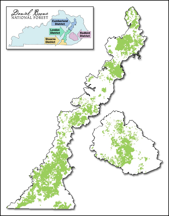
| وصف |
English: Map of Daniel Boone National Forest showing proclamation boundary and lands actually owned by the Forest Service, as of March 15, 2006. Inset map shows ranger districts. |
| تاريخ | |
| مصدر | http://www.fs.usda.gov/detail/dbnf/about-forest/?cid=stelprdb5277049 |
| مؤلف | webpage cites Author as Lands Staff. |
| سماح (إعادة استخدام الملف ده) |
http://www.fs.fed.us/privacy.shtml states: Information presented on this website is considered public information and may be distributed or copied unless otherwise indicated. Use of appropriate byline/photo/image credit is requested. |
الترخيص
This image is a work of the Forest Service of the United States Department of Agriculture. As a work of the U.S. federal government, the image is in the public domain.
|
تاريخ الفايل
اضغط على الساعه/التاريخ علشان تشوف الفايل زى ما كان فى الوقت ده.
| الساعه / التاريخ | صورة صغيرة | ابعاد | يوزر | تعليق | |
|---|---|---|---|---|---|
| دلوقتي | 01:49، 21 سبتمبر 2006 | | 580 × 740 (241 كيلوبايت) | Pfly | {{Information |Description=Map of Daniel Boone National Forest showing proclamation boundary and lands actually owned by the Forest Service, as of March 15, 2006. Inset map shows ranger districts. |Source=http://www.fs.fed.us/r8/boone/aboutus/ownership.s |
استخدام الفايل
ال1 صفحة دى فيها وصله للفايل ده:
استخدام الملف العام
الويكيات التانيه دى بتستخدم الفايل ده:
- الاستخدام ف ca.wikipedia.org
- الاستخدام ف de.wikipedia.org
- الاستخدام ف es.wikipedia.org
- الاستخدام ف www.wikidata.org