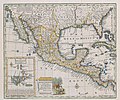
ملف:Bowen Mexico or New Spain 1752 UTA.jpg

حجم البروفه دى: 716 × 599 بكسل. الأبعاد التانيه: 287 × 240 بكسل | 574 × 480 بكسل | 918 × 768 بكسل | 1,223 × 1,024 بكسل | 2,447 × 2,048 بكسل | 2,664 × 2,230 بكسل.
الصوره الاصليه (2,664 × 2,230 بكسل حجم الفايل: 7.49 ميجابايت، نوع MIME: image/jpeg)
تاريخ الفايل
اضغط على الساعه/التاريخ علشان تشوف الفايل زى ما كان فى الوقت ده.
| الساعه / التاريخ | صورة صغيرة | ابعاد | يوزر | تعليق | |
|---|---|---|---|---|---|
| دلوقتي | 21:25، 3 يوليه 2019 |  | 2,664 × 2,230 (7.49 ميجابايت) | Michael Barera | == {{int:filedesc}} == {{Map |title = ''A New & Accurate Map of Mexico or New Spain together with California, New Mexico &c'' |description = {{en|The cartouche of this map of New Spain depicts a European mishandling a couple of Native American captives. The image dates at least back to 1729 when Peter Van der Aa included an identical image on his cartouche of a map of Mexico or New Spain appearing in Abraham du Bois' ''La Geographie Moderne'', published in Leiden at that d... |
استخدام الفايل
ال1 صفحة دى فيها وصله للفايل ده:
استخدام الملف العام
الويكيات التانيه دى بتستخدم الفايل ده:
- الاستخدام ف de.wikipedia.org
- الاستخدام ف en.wikipedia.org
- الاستخدام ف es.wikipedia.org
- الاستخدام ف fr.wikipedia.org
- الاستخدام ف hr.wikipedia.org
- الاستخدام ف la.wikipedia.org


