ملف:Carte du Mitanni.png

حجم البروفه دى: 800 × 534 بكسل. الأبعاد التانيه: 320 × 214 بكسل | 640 × 427 بكسل | 1,024 × 683 بكسل | 1,272 × 849 بكسل.
الصوره الاصليه (1,272 × 849 بكسل حجم الفايل: 1.51 ميجابايت، نوع MIME: image/png)
| وصف |
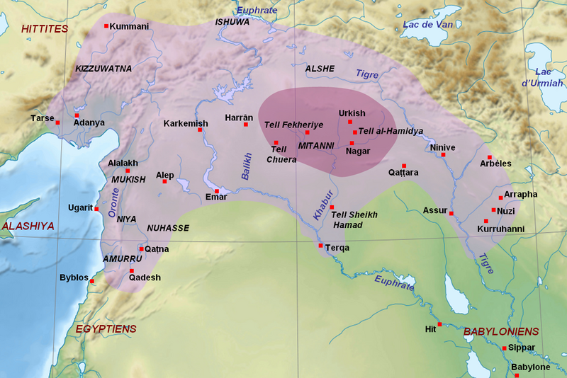
English: Map of the kingdom of Mitanni at its maximal extension, with the main cities and archaeological sites. Adapted from F. Joannès (dir.), Dictionnaire de la civilisation mésopotamienne, Paris, 2001, p. 534 (map by M. Sauvage and B. Lion), and M. Roaf, Cultural Atlas of Mesopotamia and the Ancient Near East, Oxford, 2004, p. 134 with the addition of Terqa among the vassals of Mitanni. Dark purple : the mitannian heartland ; light purple : the approximate maximal extension of the mitannian dominion.
Français : Carte du royaume du Mitanni avec ses limites approximatives à son apogée avec les principales villes et sites archéologiques. Adapté de F. Joannès (dir.), Dictionnaire de la civilisation mésopotamienne, Paris, 2001, p. 534 (carte de M. Sauvage et B. Lion), et M. Roaf, Cultural Atlas of Mesopotamia and the Ancient Near East, Oxford, 2004, p. 134, avec l'ajout de Terqa parmi les vassaux du Mitanni. Mauve foncé : le cœur du Mitanni ; mauve clair : les limites approximatives de l'extension maximale de la domination du Mitanni au début du XVe siècle av. J.-C. |
| تاريخ | (UTC) |
| مصدر | |
| مؤلف |
|
| إصدارات أخرى |
[]
|


| هذا رسمٌ مُعَدَّلٌ رقميَّاً من النسخة الأصليَّة. التعديلات هي: Ajout des sites du Mitanni et de l'étendue du royaume. يُمكن الاطلاع على النسخة الأصليَّة هنا: Near East topographic map-blank.svg:
|
أنا، صاحب حقوق التأليف والنشر لهذا العمل، أنشر هذا العمل تحت الرخص التالية:
- إنت حر:
- فى المشاركه – علشان نسخ و توزيع و بث العمل
- إنك تمزج – فى تكييف العمل
- بالشروط دى:
- نسبه ل – لازم يتنسب العمل للى مألفه بشكل مناسب و توفير رابط للرخصه وتحديد اذا حصلت تغييرات. ممكن ده يتعمل بأى طريقه معقوله، لكن مش بطريقه تشير ان مانح الرخصه بيوافقك على الاستعمال.
- مشاركه زي – لو عدت إنتاج المواد أو غيرت فيها، لازم تنشر مساهماتك اللى جايه من الأصل تحت ترخيص الأصل نفسه أو تحت ترخيص متوافق معاه.

|
يسمح بنسخ و توزيع و / أو تعديل الوثيقه دى تحت شروط رخصة جنو للوثائق الحره، الإصدار 1.2 أو أى إصدار تنشره مؤسسة البرمجيات الحره؛ بدون أقسام ثابته و بدون نصوص أغلفه أماميه و بدون نصوص أغلفه خلفيه. نسخه من الرخصه متضمنه ف قسم اسمه GNU Free Documentation License. |
اختار الرخصه اللى تناسبك.
سجلُّ الرَّفع الأصيل
This image is a derivative work of the following images:
- File:Near_East_topographic_map-blank.svg licensed with Cc-by-sa-3.0,2.5,2.0,1.0, GFDL
- 2009-08-18T18:31:37Z Sémhur 2425x1581 (2442670 Bytes) 3 - New try
- 2009-08-17T15:39:22Z Sémhur 2425x1581 (1815374 Bytes) 2 - With the background...
- 2009-08-17T15:37:36Z Sémhur 2425x1581 (2836 Bytes) {{Information |Description={{en|1=Blank physical map of the [[:en:Near East|Near East]]}} {{fr|1=Carte physique vierge du [[:fr:Proche-Orient|Proche-Orient]].}} |Source={{own}} |Author=[[User:Sémhur|Sémhur]] |Date=2008-08-1
Uploaded with derivativeFX
تاريخ الفايل
اضغط على الساعه/التاريخ علشان تشوف الفايل زى ما كان فى الوقت ده.
| الساعه / التاريخ | صورة صغيرة | ابعاد | يوزر | تعليق | |
|---|---|---|---|---|---|
| دلوقتي | 14:00، 23 سبتمبر 2010 | | 1,272 × 849 (1.51 ميجابايت) | Zunkir | Ajout de Qattara, corrections mineures. |
| 13:57، 23 سبتمبر 2010 |  | 1,272 × 849 (1.51 ميجابايت) | Zunkir | Coloriage de l'extension du Mitanni, et de sa région centrale, ajout de villes et des noms des cours d'eau. | |
| 11:49، 21 سبتمبر 2010 |  | 1,173 × 797 (1.42 ميجابايت) | Zunkir | {{Information |Description={{en|1=Map of the kingdom of Mitanni at its maximal extension, with the main cities and archeological sites.}} {{fr|Carte du royaume du Mitanni à son apogée avec les principales villes et sites archéologiques.}} |Source=*[[: |
استخدام الفايل
ال1 صفحة دى فيها وصله للفايل ده:
استخدام الملف العام
الويكيات التانيه دى بتستخدم الفايل ده:
- الاستخدام ف am.wikipedia.org
- الاستخدام ف ar.wikipedia.org
- الاستخدام ف ast.wikipedia.org
- الاستخدام ف ba.wikipedia.org
- الاستخدام ف be-tarask.wikipedia.org
- الاستخدام ف bg.wikipedia.org
- الاستخدام ف bn.wikipedia.org
- الاستخدام ف br.wikipedia.org
- الاستخدام ف ceb.wikipedia.org
- الاستخدام ف ckb.wikipedia.org
- الاستخدام ف cs.wikipedia.org
- الاستخدام ف de.wikipedia.org
- الاستخدام ف el.wikipedia.org
- الاستخدام ف en.wikipedia.org
- الاستخدام ف eo.wikipedia.org
- الاستخدام ف fa.wikipedia.org
- الاستخدام ف fi.wikipedia.org
- الاستخدام ف fr.wikipedia.org
- الاستخدام ف gl.wikipedia.org
- الاستخدام ف hi.wikipedia.org
- الاستخدام ف id.wikipedia.org
- الاستخدام ف it.wikipedia.org
- الاستخدام ف ja.wikipedia.org
- الاستخدام ف lt.wikipedia.org
- الاستخدام ف lv.wikipedia.org
- الاستخدام ف ne.wikipedia.org
- الاستخدام ف nl.wikipedia.org
- الاستخدام ف pl.wikipedia.org
اعرض استخدام عام اكتر للملف ده.