ملف:Celts in Europe-fr.svg

حجم معاينة PNG لذلك الملف ذي الامتداد SVG: 800 × 592 بكسل. الأبعاد التانيه: 320 × 237 بكسل | 640 × 473 بكسل | 1,024 × 757 بكسل | 1,280 × 947 بكسل | 2,560 × 1,893 بكسل | 933 × 690 بكسل.
الصوره الاصليه (ملف SVG، اساسا 933 × 690 بكسل، حجم الملف: 165 كيلوبايت)
الخلاصة
| وصف |
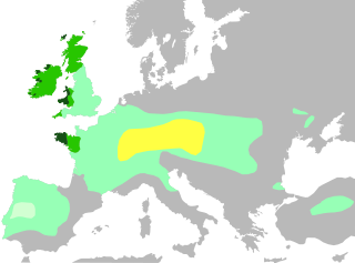
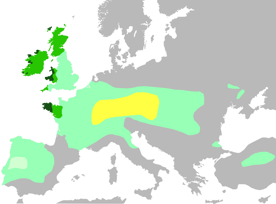
Français : Cette carte montre :
Noyau territorial Hallstatt, au VI siècle avant J.-C.
Expansion celtique maximale, en 275 avant J.-C.
Domaine lusitanien de l'Ibérie où la présence celtique est incertaine
Les six nations celtiques officielles aujourd'hui et qui pratiquaient le langage celtique au Moyen Âge (Bretagne, Pays de Galles, Cornouailles, Ile de Man, Irlande, Ecosse)
Zones où les langues celtiques restent largement parlées aujourd'hui English: Celts in Europe
the core Hallstatt territory, expansion before 500 BCE
maximum Celtic expansion by the 270s BCE
Lusitanian area of Iberia, "Celticity" uncertain
the boundaries of the six commonly-recognized 'Celtic nations', which remained Celtic speaking throughout the Middle Ages (viz. Brittany, Wales, Cornwall, Isle of Man, Ireland, Scotland)
areas that remain Celtic-speaking today Deutsch: Verbreitung keltischer Völker und Sprachen: Gebiet der Hallstatt-Kultur im 6. Jahrhundert v. Chr.
Größte keltische Ausdehnung, um 275 v. Chr.
Lusitania (keltische Besiedlung unsicher)
Die „sechs Keltischen Nationen“ in denen es bis in die Frühe Neuzeit eine signifikante Anzahl Sprecher keltischer Sprachen gab.
Das heutige Verbreitungsgebiet keltischer Sprachen |
| تاريخ | |
| مصدر | |
| مؤلف | QuartierLatin1968, The Ogre, Dbachmann, Superwikifan; derivative work Augusta 89 |
| إصدارات أخرى |
|

الترخيص
أنا، صاحب حقوق التأليف والنشر لهذا العمل، أنشر هذا العمل تحت الرخصة التالية:
الملف ده مترخص حسب رخصة المشاع الإبداعى نسبة المصنف للى مألفه - المشاركة بالمثل 3.0 العامه
- إنت حر:
- فى المشاركه – علشان نسخ و توزيع و بث العمل
- إنك تمزج – فى تكييف العمل
- بالشروط دى:
- نسبه ل – لازم يتنسب العمل للى مألفه بشكل مناسب و توفير رابط للرخصه وتحديد اذا حصلت تغييرات. ممكن ده يتعمل بأى طريقه معقوله، لكن مش بطريقه تشير ان مانح الرخصه بيوافقك على الاستعمال.
- مشاركه زي – لو عدت إنتاج المواد أو غيرت فيها، لازم تنشر مساهماتك اللى جايه من الأصل تحت ترخيص الأصل نفسه أو تحت ترخيص متوافق معاه.
تاريخ الفايل
اضغط على الساعه/التاريخ علشان تشوف الفايل زى ما كان فى الوقت ده.
| الساعه / التاريخ | صورة صغيرة | ابعاد | يوزر | تعليق | |
|---|---|---|---|---|---|
| دلوقتي | 18:35، 4 نوفمبر 2016 | | 933 × 690 (165 كيلوبايت) | Rob984 | Adjusted colour of sea and land to conform to widely used grey-white style, which I think looks better. Adds focus on the colour part of the map. |
| 16:04، 3 يوليه 2014 |  | 933 × 695 (274 كيلوبايت) | Kopiersperre | same colours like in File:Celts in Europe.png | |
| 12:04، 14 يونيه 2014 |  | 933 × 695 (274 كيلوبايت) | Augusta 89 | User created page with UploadWizard |
استخدام الفايل
ال1 صفحة دى فيها وصله للفايل ده:
استخدام الملف العام
الويكيات التانيه دى بتستخدم الفايل ده:
- الاستخدام ف ast.wikipedia.org
- الاستخدام ف ca.wikipedia.org
- الاستخدام ف de.wikipedia.org
- الاستخدام ف de.wikivoyage.org
- الاستخدام ف en.wikipedia.org
- الاستخدام ف es.wikipedia.org
- الاستخدام ف eu.wikipedia.org
- الاستخدام ف fr.wikipedia.org
- الاستخدام ف fr.wikibooks.org
- الاستخدام ف ga.wikipedia.org
- الاستخدام ف gl.wikipedia.org
- الاستخدام ف hu.wikipedia.org
- الاستخدام ف lv.wikipedia.org
- الاستخدام ف pcd.wikipedia.org
- الاستخدام ف pt.wikipedia.org
- الاستخدام ف rm.wikipedia.org
- الاستخدام ف vec.wikipedia.org
- الاستخدام ف www.wikidata.org
- الاستخدام ف zh.wikipedia.org