الصوره الاصليه (1,592 × 1,143 بكسل حجم الفايل: 3.22 ميجابايت، نوع MIME: image/png)

الملف دا من ويكيميديا كومنز و ممكن تستعمله المشاريع التانيه. الوصف بتاعه صفحة وصف الملف هناك معروض تحت..

هذه map الصورة / الصورتان باستعمال رسومات متجهية ملفات رسوميات شعاعية. It is recommended to name the SVG file "Chehalis.svg" - then the template Vector version available (or Vva) does not need the new image name parameter.

الخلاصة

وصف
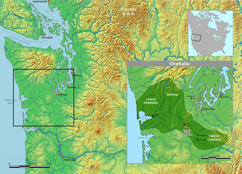
English: Map of traditional Chehalis tribal territory.
تاريخ
مصدر Own work using: background map courtesy of Demis, www.demis.nl
مؤلف User:Nikater
سماح
(إعادة استخدام الملف ده)
Public domain
This image is in the public domain because it came from the site https://www.demis.nl/products/web-map-server/examples/ and was released by the copyright holder. Permission is granted to copy, distribute and/or modify this map since it is based on free of copyright images from: www.demis.nl. See also approval email on de.wp and its clarification.

Deutsch | English | македонски | മലയാളം | Nederlands | slovenščina | +/−

Public domain This work has been released into the public domain by its copyright holder, www.demis.nl. This applies worldwide.
في بعض البلدان، قد يكون هذا التَّرخيص غيرَ مُمكنٍ قانونيَّاً، في هذه الحالة:
يمنح www.demis.nl الجميع حق استخدام هذا العمل لأي غرض دون أي شرط ما لم يفرض القانون شروطًا إضافية.

الشروحات

أضف شرحاً من سطر واحد لما يُمثِّله هذا الملف
Topographic map of the Pacific Northwest with an inset showing Chehalis tribal territory.

العناصر المصورة في هذا الملف

يُصوِّر العربية

6 ديسمبر 2007

نوع الوسائط العربية

image/png

604df0cc85656e1e9c1193e8a09e77788f327037

حجم البيانات العربية

3,373,109 بايت

الارتفاع العربية

1,143 بكسل

1,592 بكسل

تاريخ الفايل

اضغط على الساعه/التاريخ علشان تشوف الفايل زى ما كان فى الوقت ده.

الساعه / التاريخصورة صغيرةابعاديوزرتعليق
دلوقتي21:17، 5 مايو 2011تصغير للنسخة بتاريخ 21:17، 5 مايو 20111,592 × 1,143 (3.22 ميجابايت)NikaterRahmen für kleine Karte eingefügt
20:58، 5 مايو 2011تصغير للنسخة بتاريخ 20:58، 5 مايو 20111,592 × 1,143 (3.22 ميجابايت)NikaterKarte überarbeitet und ergänzt
07:54، 6 ديسمبر 2007تصغير للنسخة بتاريخ 07:54، 6 ديسمبر 20071,497 × 1,056 (2.65 ميجابايت)Nikater{{Information |Description=Map of traditional Chehalis tribal territory. |Source=Own work by Nikater, submitted to the public domain. Background map courtesy of Demis, www.demis.nl |Date=6 December 2007 |Author=User:Nikater |Permission={{PD-Demis}} }}

ال1 صفحة دى فيها وصله للفايل ده:

استخدام الملف العام

الويكيات التانيه دى بتستخدم الفايل ده: