ملف:Detailed map of Benson, Arizona.png
مافيش ريزوليوشن اعلى متوفر.
Detailed_map_of_Benson,_Arizona.png (575 × 425 بكسل حجم الفايل: 24 كيلوبايت، نوع MIME: image/png)

|
هذه city map الصورة / الصورتان باستعمال رسومات متجهية ملفات رسوميات شعاعية.
It is recommended to name the SVG file "Detailed map of Benson, Arizona.svg" - then the template Vector version available (or Vva) does not need the new image name parameter.
|
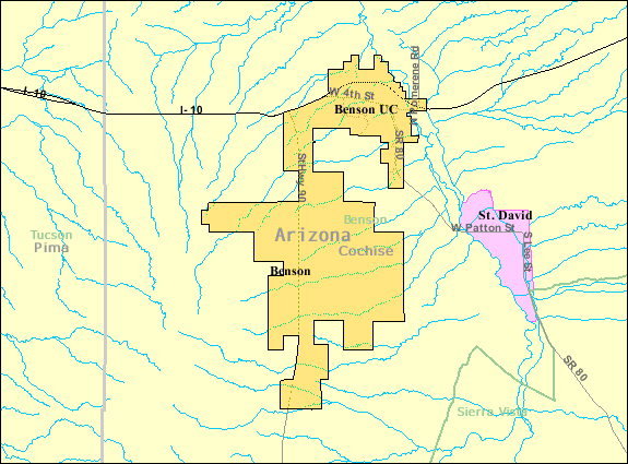
| وصف | Map of Benson, a city in Cochise County, Arizona, United States, with its boundaries at the time of the 2000 census. | |||
| تاريخ | تاريخ مش معروف; downloaded by me on 13 December 2008 | |||
| مصدر | http://factfinder.census.gov/leg2/46/120825446.gif, from http://factfinder.census.gov | |||
| مؤلف | United States Census Bureau | |||
| سماح (إعادة استخدام الملف ده) |
|

تاريخ الفايل
اضغط على الساعه/التاريخ علشان تشوف الفايل زى ما كان فى الوقت ده.
| الساعه / التاريخ | صورة صغيرة | ابعاد | يوزر | تعليق | |
|---|---|---|---|---|---|
| دلوقتي | 01:57، 14 ديسمبر 2008 | | 575 × 425 (24 كيلوبايت) | Nyttend | {{Information |Description=Map of {{w|Benson, Arizona|Benson}}, a city in {{w|Cochise County, Arizona|Cochise County}}, {{w|Arizona}}, {{w|United States}}, with its boundaries at the time of the {{w|2000 United States Census|2000 census}}. |Source=http:// |
استخدام الفايل
ال1 صفحة دى فيها وصله للفايل ده:
استخدام الملف العام
الويكيات التانيه دى بتستخدم الفايل ده:
- الاستخدام ف ar.wikipedia.org
- الاستخدام ف azb.wikipedia.org
- الاستخدام ف ca.wikipedia.org
- الاستخدام ف ceb.wikipedia.org
- الاستخدام ف en.wikipedia.org
- الاستخدام ف eu.wikipedia.org
- الاستخدام ف fa.wikipedia.org
- الاستخدام ف fr.wikipedia.org
- الاستخدام ف sr.wikipedia.org
- الاستخدام ف sv.wikipedia.org
- الاستخدام ف tt.wikipedia.org
- الاستخدام ف ur.wikipedia.org
- الاستخدام ف www.wikidata.org
- الاستخدام ف zh-min-nan.wikipedia.org
- الاستخدام ف zh.wikipedia.org