ملف:Dioecesis Thraciae 400 AD.png
مافيش ريزوليوشن اعلى متوفر.
Dioecesis_Thraciae_400_AD.png (461 × 352 بكسل حجم الفايل: 205 كيلوبايت، نوع MIME: image/png)
الخلاصة
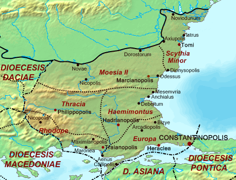
| وصف | Map of the Diocese of Thrace (Dioecesis Thraciae) ca. 400 AD, showing the subordinate provinces and the major cities. |
| تاريخ | |
| مصدر |
Base map found at en:Topographic map#Global 1-kilometer map, otherwise self-made. Data based on maps in atlases and the internet and on contemporary sources, primarily the Notitia Dignitatum. Note: The exact course of the provincial boundaries is very uncertain and in many cases only approximate. |
| مؤلف | Cplakidas |
الترخيص
| أنا، مالِك حقوق تأليف ونشر هذا العمل، أجعله في النِّطاق العامِّ، يسري هذا في أرجاء العالم كلِّه. في بعض البلدان، قد يكون هذا التَّرخيص غيرَ مُمكنٍ قانونيَّاً، في هذه الحالة: أمنح الجميع حق استخدام هذا العمل لأي غرض دون أي شرط ما لم يفرض القانون شروطًا إضافية. |
تاريخ الفايل
اضغط على الساعه/التاريخ علشان تشوف الفايل زى ما كان فى الوقت ده.
| الساعه / التاريخ | صورة صغيرة | ابعاد | يوزر | تعليق | |
|---|---|---|---|---|---|
| دلوقتي | 14:30، 20 مايو 2017 | | 461 × 352 (205 كيلوبايت) | Julieta39 | Antic shoreline of the Danube mouths since Grigore Antipa's "Black Sea" (1940) and Andrei Nacu's paleomap [https://fr.wikipedia.org/wiki/Delta_du_Danube#/media/File:Danube_Delta_evolution.gif]. |
| 16:25، 2 اكتوبر 2007 |  | 461 × 352 (139 كيلوبايت) | Cplakidas | {{Information |Description=Map of the Diocese of Thrace (''Dioecesis Thraciae'') ca. 400 AD, showing the subordinate provinces and the major cities. |Source=Base map found at en:Topographic map#Global 1-kilometer map, other |
استخدام الفايل
ال2 صفحة دى فيها وصله للفايل ده:
استخدام الملف العام
الويكيات التانيه دى بتستخدم الفايل ده:
- الاستخدام ف an.wikipedia.org
- الاستخدام ف ar.wikipedia.org
- الاستخدام ف az.wikipedia.org
- الاستخدام ف be.wikipedia.org
- الاستخدام ف bg.wikipedia.org
- الاستخدام ف ca.wikipedia.org
- الاستخدام ف cs.wikipedia.org
- الاستخدام ف da.wikipedia.org
- الاستخدام ف de.wikipedia.org
- الاستخدام ف de.wikivoyage.org
- الاستخدام ف el.wikipedia.org
- الاستخدام ف en.wikipedia.org
- الاستخدام ف es.wikipedia.org
اعرض استخدام عام اكتر للملف ده.