ملف:East-Hem 1100ad.jpg

الصوره الاصليه (3,240 × 1,903 بكسل حجم الفايل: 3.16 ميجابايت، نوع MIME: image/jpeg)

|
هذه historical map الصورة / الصورتان باستعمال رسومات متجهية ملفات رسوميات شعاعية.
It is recommended to name the SVG file "East-Hem 1100ad.svg" - then the template Vector version available (or Vva) does not need the new image name parameter.
|


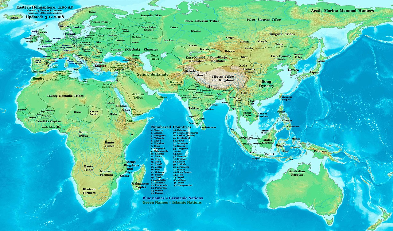
| وصف | Eastern Hemisphere in 1100 AD. |
| مصدر | self-made (For reference information, see the Map Source References section below.) |
| مؤلف | Thomas Lessman (Contact!) |
| سماح (إعادة استخدام الملف ده) |
أنا، صاحب حقوق التأليف والنشر لهذا العمل، أنشر هذا العمل تحت الرخصة التالية: الملف ده مترخص حسب رخصة المشاع الإبداعى نسبة المصنف للى مألفه - المشاركة بالمثل 3.0 العامه
|
| إصدارات أخرى | see East-Hem_1100ad.jpg file history on Wikipedia. |
Map Summary
Original Source URL: http://www.thomaslessman.com/History/images/East-Hem_1100ad.jpg.
This map of the Eastern Hemisphere in 1100 AD was created by Thomas Lessman, based on information from the sources listed below. This map is free for educational use (see Permission info above). When using this map, please mention that it is available for free at www.WorldHistoryMaps.info.
Keep in mind that sources often conflict with each other, and they are as accurate as the information that is available to me. To report any errors, or if you want to help further this work, please see here, or email Thomas Lessman at talessman@yis.us.
Map Source References
- Remember, sources often conflict with each other. This map is only as accurate as the information that is available to me. To report any errors or to help further this work, please click here, or email Thomas Lessman at talessman@yis.us
References for information contained in this map:
1. Borders of Europe are mostly derived from the www.Euratlas.com map of Europe in 1100 AD.
- (Please note: Bogomolov.PL has done a great job of showing me possible discrepancies in my north European borders compared to this source, due to the differences in the geographical layout of the maps.)
2. Borders of Asian countries derive from various Wikipedia articles and Google history map searches.
3. Much of the information in this map was cross-checked with Bruce Gordon's Regnal Chronologies.
Other Maps by Thomas Lessman
| Maps of the eastern hemisphere showing history
Bold dates are available on Wikimedia or Wikipedia. | ||
| Primeval | ||
| Ancient
|
·| 600 BC | 550 BC | 527 BC | 500 BC |
400 BC | ·| 1 AD | 50 AD | 100 AD | 200 AD | 300 AD | | |
| Medieval |
·| 500 AD | 565 AD | 600 AD | 700 AD | | |
| Modern |
·| 1500 AD | · * For historical maps of the whole world, | |
Other Info
تاريخ الفايل
اضغط على الساعه/التاريخ علشان تشوف الفايل زى ما كان فى الوقت ده.
| الساعه / التاريخ | صورة صغيرة | ابعاد | يوزر | تعليق | |
|---|---|---|---|---|---|
| دلوقتي | 11:16، 16 يناير 2009 | | 3,240 × 1,903 (3.16 ميجابايت) | Ukabia | {{Information |Description= |Source= |Date= |Author= |Permission= |other_versions= }} |
| 20:46، 9 مايو 2008 |  | 3,240 × 1,903 (782 كيلوبايت) | Talessman | {{Information |Description=Eastern Hemisphere in 1100 AD. |Source=self-made |Author=Thomas Lessman |Permission={{self|cc-by-sa-3.0}} }} |
استخدام الفايل
ال1 صفحة دى فيها وصله للفايل ده:
استخدام الملف العام
الويكيات التانيه دى بتستخدم الفايل ده:
- الاستخدام ف azb.wikipedia.org
- الاستخدام ف be.wikipedia.org
- الاستخدام ف bs.wikipedia.org
- الاستخدام ف de.wikipedia.org
- الاستخدام ف de.wikiversity.org
- الاستخدام ف en.wikipedia.org
- الاستخدام ف es.wikipedia.org
- الاستخدام ف et.wikipedia.org
- الاستخدام ف fr.wikipedia.org
- الاستخدام ف gl.wikipedia.org
- الاستخدام ف hu.wikipedia.org
- الاستخدام ف mk.wikipedia.org
- الاستخدام ف mr.wikipedia.org
- الاستخدام ف my.wikipedia.org
- الاستخدام ف nn.wikipedia.org
- الاستخدام ف ro.wikipedia.org
- الاستخدام ف rue.wikipedia.org
- الاستخدام ف shn.wikipedia.org
- الاستخدام ف sh.wikipedia.org
- الاستخدام ف si.wikipedia.org
- الاستخدام ف sv.wikipedia.org
- الاستخدام ف sw.wikipedia.org
- الاستخدام ف ta.wikipedia.org
- الاستخدام ف tl.wikipedia.org
- الاستخدام ف uk.wikipedia.org
- الاستخدام ف ur.wikipedia.org
- الاستخدام ف vi.wikipedia.org