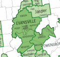
ملف:EvansvilleMSA-Census04.gif
EvansvilleMSA-Census04.gif (480 × 450 بكسل حجم الفايل: 39 كيلوبايت، نوع MIME: image/gif)
تاريخ الفايل
اضغط على الساعه/التاريخ علشان تشوف الفايل زى ما كان فى الوقت ده.
| الساعه / التاريخ | صورة صغيرة | ابعاد | يوزر | تعليق | |
|---|---|---|---|---|---|
| دلوقتي | 22:32، 13 سبتمبر 2008 |  | 480 × 450 (39 كيلوبايت) | Randella | == Summary == This is a representation of the Evansville, IN-KY Metropolitan Statistical Area. I created this image using a U.S. Census Bureau map image from [http://www.census.gov/geo/www/maps/msa_maps2004/us_wall_1104.htm Metropolitan and Micropoli |
استخدام الفايل
ال2 صفحة دى فيها وصله للفايل ده:
استخدام الملف العام
الويكيات التانيه دى بتستخدم الفايل ده:
- الاستخدام ف en.wikipedia.org
- Webster County, Kentucky
- Henderson County, Kentucky
- Warrick County, Indiana
- Vanderburgh County, Indiana
- Posey County, Indiana
- Princeton, Indiana
- Mount Vernon, Indiana
- New Harmony, Indiana
- Evansville, Indiana
- Boonville, Indiana
- Chandler, Indiana
- Newburgh, Indiana
- Henderson, Kentucky
- University of Southern Indiana
- ITT Technical Institute
- Vincennes University
- University of Evansville
- Ivy Tech Community College of Indiana
- Oakland City University
- Southwestern Indiana
- Evansville metropolitan area
- Template:Evansville Metropolitan Area
- Template:Colleges and Universities in Metropolitan Evansville
- Harrison College (Indiana)
- File talk:EvansvilleMSA-Census04.gif
- User:Crtew
- Illinois–Indiana–Kentucky tri-state area
- الاستخدام ف es.wikipedia.org
- الاستخدام ف fa.wikipedia.org
- الاستخدام ف ur.wikipedia.org
- الاستخدام ف www.wikidata.org

