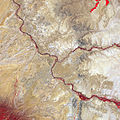
ملف:Four Corners, Southwestern U.S.jpg

حجم البروفه دى: 600 × 600 بكسل. الأبعاد التانيه: 240 × 240 بكسل | 480 × 480 بكسل | 768 × 768 بكسل | 1,024 × 1,024 بكسل | 2,200 × 2,200 بكسل.
الصوره الاصليه (2,200 × 2,200 بكسل حجم الفايل: 2.73 ميجابايت، نوع MIME: image/jpeg)
تاريخ الفايل
اضغط على الساعه/التاريخ علشان تشوف الفايل زى ما كان فى الوقت ده.
| الساعه / التاريخ | صورة صغيرة | ابعاد | يوزر | تعليق | |
|---|---|---|---|---|---|
| دلوقتي | 08:35، 26 سبتمبر 2011 |  | 2,200 × 2,200 (2.73 ميجابايت) | Originalwana | {{Information |Description ={{en|1=Satellite image of the Four Corners. Vegetation is red, and sparsely vegetated or bare areas range from off-white to gray to tan. Water appears navy blue to nearly black. Vegetation (bright red |
استخدام الفايل
ال1 صفحة دى فيها وصله للفايل ده:
استخدام الملف العام
الويكيات التانيه دى بتستخدم الفايل ده:
- الاستخدام ف ar.wikipedia.org
- الاستخدام ف ca.wikipedia.org
- الاستخدام ف ceb.wikipedia.org
- الاستخدام ف cs.wikipedia.org
- الاستخدام ف en.wikipedia.org
- الاستخدام ف eo.wikipedia.org
- الاستخدام ف es.wikipedia.org
- الاستخدام ف fa.wikipedia.org
- الاستخدام ف fr.wikipedia.org
- الاستخدام ف he.wikipedia.org
- الاستخدام ف hy.wikipedia.org
- الاستخدام ف it.wikivoyage.org
- الاستخدام ف ja.wikipedia.org
- الاستخدام ف ro.wikipedia.org
- الاستخدام ف www.wikidata.org

