ملف:Lakeside Mountains, Utah (21695777605).jpg

الصوره الاصليه (4,000 × 3,000 بكسل حجم الفايل: 2.14 ميجابايت، نوع MIME: image/jpeg)
.jpg)
الخلاصة
| وصف |
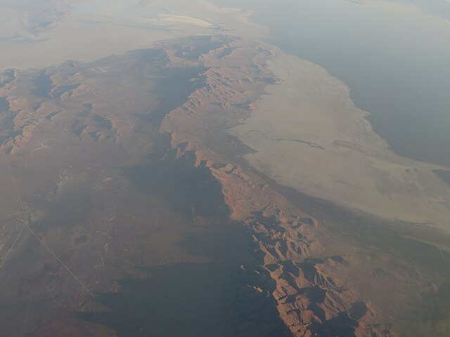
The Lakeside Mountains are about a 34-mile-long (55 km) mountain range located on the southwest perimeter of the Great Salt Lake; the range is located in northeast Tooele County, Utah, and south Box Elder County. The range consists of a 13-mile-long north-trending section, and a southeast stretch composed of variable-height peaks and lower elevations, as well as a massif section containing the mountain range highpoint. The north section of the range terminus is at the community of Lakeside, Utah, and the region lies on an eastern border of the Great Salt Lake Desert. The range is linear, with the two trending sections. The north section actually trends slightly north-northeast, with the south part of it as a mountain area, with Sally Mountain, 5,855 feet (1,785 m); north of it, the range turns into ridgelines and small parallel valleys. Interstate 80 crosses the southern terminus of the Lakeside Mountains, at the townsite of Delle. A northwest stretch of I-80 from Delle, skirts the range foothills, then enters the north of the Cedar Mountains, before turning west through the Great Salt Lake Desert. From the north Cedar Mountains, Puddle Valley Highway (improved road) transits due-north through Puddle Valley, then enters the west flank region of the north section of the range; a small valley called "Death Valley", located in a hilly foothill region, borders the Great Salt Lake Desert, on the desert's east, about 3 mi; Death Ridge, a subridge is 1 mi east; the north mountain terminus near Lakeside continues as named: Scad Ridge, Sedal Valley, Cave Ride, Great Salt Lake shoreline, (all 1 mi apart from each other). <a href="https://en.wikipedia.org/wiki/Lakeside_Mountains" rel="noreferrer nofollow">en.wikipedia.org/wiki/Lakeside_Mountains</a> <a href="https://en.wikipedia.org/wiki/Wikipedia:Text_of_Creative_Commons_Attribution-ShareAlike_3.0_Unported_License" rel="noreferrer nofollow">en.wikipedia.org/wiki/Wikipedia:Text_of_Creative_Commons_...</a> |
| تاريخ | |
| مصدر | Lakeside Mountains, Utah |
| مؤلف | Ken Lund from Reno, Nevada, USA |
| موقع الكاميرا | | هذه وغيرها من الصور في مواقعها على: خريطة الشارع المفتوحة |
|---|
.jpg¶ms=041.005033_N_-112.884479_E_globe:Earth_type:camera_source:Flickr_&language=arz)
الترخيص
- إنت حر:
- فى المشاركه – علشان نسخ و توزيع و بث العمل
- إنك تمزج – فى تكييف العمل
- بالشروط دى:
- نسبه ل – لازم يتنسب العمل للى مألفه بشكل مناسب و توفير رابط للرخصه وتحديد اذا حصلت تغييرات. ممكن ده يتعمل بأى طريقه معقوله، لكن مش بطريقه تشير ان مانح الرخصه بيوافقك على الاستعمال.
- مشاركه زي – لو عدت إنتاج المواد أو غيرت فيها، لازم تنشر مساهماتك اللى جايه من الأصل تحت ترخيص الأصل نفسه أو تحت ترخيص متوافق معاه.
| نَشَر Ken Lund هذه الصُّورة على موقع فلِيكر بتاريخ https://flickr.com/photos/75683070@N00/21695777605. ورَاجَعها FlickreviewR 2 في 31 مارس 2022، وتأكَّدَ أَنَّها مُرخَّصة برخصة cc-by-sa-2.0. |
تاريخ الفايل
اضغط على الساعه/التاريخ علشان تشوف الفايل زى ما كان فى الوقت ده.
| الساعه / التاريخ | صورة صغيرة | ابعاد | يوزر | تعليق | |
|---|---|---|---|---|---|
| دلوقتي | 23:44، 31 مارس 2022 | | 4,000 × 3,000 (2.14 ميجابايت) | Animalparty | Transferred from Flickr via #flickr2commons |
استخدام الفايل
ال1 صفحة دى فيها وصله للفايل ده:
استخدام الملف العام
الويكيات التانيه دى بتستخدم الفايل ده:
- الاستخدام ف ceb.wikipedia.org
- الاستخدام ف en.wikipedia.org
- الاستخدام ف www.wikidata.org
.jpg)