ملف:Lion distribution.png
حجم البروفه دى: 687 × 600 بكسل. الأبعاد التانيه: 275 × 240 بكسل | 550 × 480 بكسل | 880 × 768 بكسل.
الصوره الاصليه (880 × 768 بكسل حجم الفايل: 51 كيلوبايت، نوع MIME: image/png)

|
هذه map الصورة / الصورتان باستعمال رسومات متجهية ملفات رسوميات شعاعية.
It is recommended to name the SVG file "Lion distribution.svg" - then the template Vector version available (or Vva) does not need the new image name parameter.
|
الخلاصة
| وصف |
Euskara: Lehoien banaketa: Berdez gaur egun, gorriz historikoki.
Suomi: Leijonan levinneisyys vanhalla ajalla.
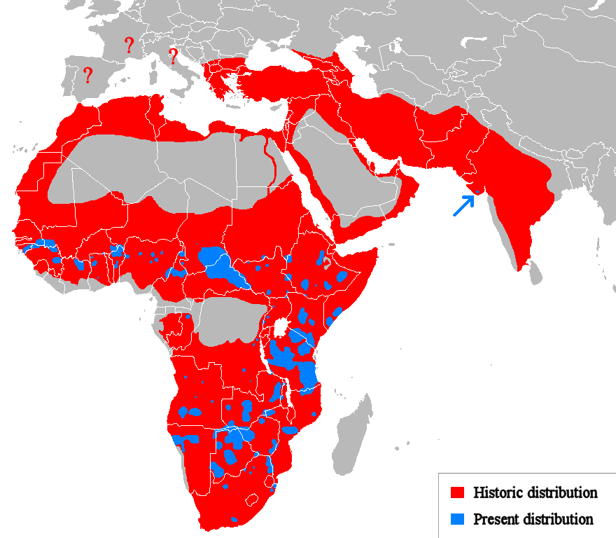
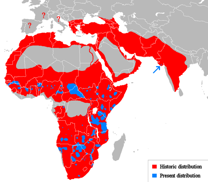
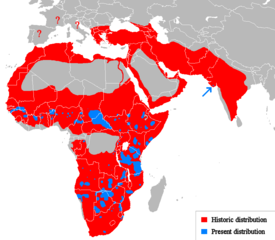
English: Geographical distribution of lions. Red (and blue) shows areas historically inhabited, blue shows areas currently inhabited.
Italiano: Areale storico (in rosso) ed attuale (in blu).
Русский: Ареал льва |
| تاريخ | (UTC) |
| مصدر |
Own work using:
|
| مؤلف | Tommyknocker (talk) |
| إصدارات أخرى | Derivative works of this file: Lion distribution-ar.png |
الترخيص
| وضع -Tommyknocker في ويكيبيديا الإنجليزية-، وهو المؤلف، هذا العمل في النِّطاق العامِّ. يسري ذلك في كل أرجاء العالم. في بعض البلدان، قد يكون هذا التَّرخيص غيرَ مُمكنٍ قانونيَّاً، في هذه الحالة: يمنح Tommyknocker الجميع حق استخدام هذا العمل لأي غرض دون أي شرط ما لم يفرض القانون شروطًا إضافية. |
سجلُّ الرَّفع الأصيل
Transferred from en.wikipedia to Commons by Egmontaz using CommonsHelper.
The original description page was here. All following user names refer to en.wikipedia.
- 2009-08-26 11:21 Tommyknocker 882×770× (42518 bytes) '
- 2009-08-24 21:02 Tommyknocker 882×770× (42434 bytes) {{Information |Description = |Source = I (~~~) created this work entirely by myself. |Date = ~~~~~ |Author = ~~~ |other_versions = }}
تاريخ الفايل
اضغط على الساعه/التاريخ علشان تشوف الفايل زى ما كان فى الوقت ده.
| الساعه / التاريخ | صورة صغيرة | ابعاد | يوزر | تعليق | |
|---|---|---|---|---|---|
| دلوقتي | 11:51، 22 مارس 2018 | | 880 × 768 (51 كيلوبايت) | Maphobbyist | Check |
| 11:23، 22 مارس 2018 |  | 880 × 768 (51 كيلوبايت) | Maphobbyist | South Sudan border | |
| 01:07، 15 مايو 2012 |  | 880 × 768 (33 كيلوبايت) | Ras67 | cropped, optimized | |
| 14:06، 19 ابريل 2010 |  | 882 × 770 (59 كيلوبايت) | MPF | Change red/green to red/blue to avoid problems for viewers with red-green colourblindness | |
| 20:00، 11 يناير 2010 |  | 882 × 770 (44 كيلوبايت) | Tommyknocker | Distribution in Southern Europe during historical times controversial, therefore now represented with question marks. | |
| 17:01، 2 نوفمبر 2009 |  | 882 × 770 (42 كيلوبايت) | File Upload Bot (Magnus Manske) | {{BotMoveToCommons|en.wikipedia|year={{subst:CURRENTYEAR}}|month={{subst:CURRENTMONTHNAME}}|day={{subst:CURRENTDAY}}}} {{Information |Description={{en|''no original description''}} |Source=Transferred from [http://en.wikipedia.org en.wikipedia]; transfer |
استخدام الفايل
ال1 صفحة دى فيها وصله للفايل ده:
استخدام الملف العام
الويكيات التانيه دى بتستخدم الفايل ده:
- الاستخدام ف ab.wikipedia.org
- الاستخدام ف af.wikipedia.org
- الاستخدام ف alt.wikipedia.org
- الاستخدام ف am.wikipedia.org
- الاستخدام ف ary.wikipedia.org
- الاستخدام ف ast.wikipedia.org
- الاستخدام ف as.wikipedia.org
- الاستخدام ف azb.wikipedia.org
- الاستخدام ف ban.wikipedia.org
- الاستخدام ف ba.wikipedia.org
- الاستخدام ف bcl.wikipedia.org
- الاستخدام ف be.wikipedia.org
- الاستخدام ف bg.wikipedia.org
- الاستخدام ف bh.wikipedia.org
- الاستخدام ف bn.wikipedia.org
- الاستخدام ف bs.wikipedia.org
- الاستخدام ف ca.wikipedia.org
- الاستخدام ف ca.wikiquote.org
- الاستخدام ف ceb.wikipedia.org
- الاستخدام ف ce.wikipedia.org
- الاستخدام ف ckb.wikipedia.org
- الاستخدام ف cs.wikipedia.org
- الاستخدام ف de.wikipedia.org
- الاستخدام ف de.wikibooks.org
- الاستخدام ف diq.wikipedia.org
- الاستخدام ف el.wikipedia.org
- الاستخدام ف en.wikipedia.org
- الاستخدام ف eo.wikipedia.org
- الاستخدام ف eo.wiktionary.org
- الاستخدام ف es.wikipedia.org
- الاستخدام ف es.wikibooks.org
- الاستخدام ف et.wikipedia.org
- الاستخدام ف eu.wikipedia.org
- الاستخدام ف ext.wikipedia.org
اعرض استخدام عام اكتر للملف ده.