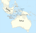
ملف:Map of Sunda and Sahul.svg

حجم معاينة PNG لذلك الملف ذي الامتداد SVG: 645 × 599 بكسل. الأبعاد التانيه: 258 × 240 بكسل | 517 × 480 بكسل | 826 × 768 بكسل | 1,102 × 1,024 بكسل | 2,204 × 2,048 بكسل | 976 × 907 بكسل.
الصوره الاصليه (ملف SVG، اساسا 976 × 907 بكسل، حجم الملف: 847 كيلوبايت)
تاريخ الفايل
اضغط على الساعه/التاريخ علشان تشوف الفايل زى ما كان فى الوقت ده.
| الساعه / التاريخ | صورة صغيرة | ابعاد | يوزر | تعليق | |
|---|---|---|---|---|---|
| دلوقتي | 08:33، 20 اغسطس 2024 |  | 976 × 907 (847 كيلوبايت) | Bjankuloski06 | File uploaded using svgtranslate tool (https://svgtranslate.toolforge.org/). Added translation for mk. |
| 23:42، 12 ابريل 2024 |  | 976 × 907 (845 كيلوبايت) | Manlleus | File uploaded using svgtranslate tool (https://svgtranslate.toolforge.org/). Added translation for ca. | |
| 23:34، 12 ابريل 2024 |  | 976 × 907 (845 كيلوبايت) | Manlleus | File uploaded using svgtranslate tool (https://svgtranslate.toolforge.org/). Added translation for ca. | |
| 15:07، 16 يناير 2023 |  | 976 × 907 (841 كيلوبايت) | Kanguole | {{Map |Description={{en|Map of Sunda and Sahul (marked by 125m depth contour) and the Wallace Line, the Weber Line and the Lydekker Line.}} |Projection=equirectangular |Latitude=-45/20.2 |Longitude=91/162.8 |Warp status=skip |Source={{own}}, using * Coastline from [http://www.naturalearthdata.com/downloads/50m-physical-vectors/ Natural Earth 1:50m Physical Vectors] * 125m depth contour derived... |
استخدام الفايل
ال1 صفحة دى فيها وصله للفايل ده:
استخدام الملف العام
الويكيات التانيه دى بتستخدم الفايل ده:
- الاستخدام ف bcl.wikipedia.org
- الاستخدام ف ca.wikipedia.org
- الاستخدام ف en.wikipedia.org
- Asia
- Land bridge
- Wallace Line
- Sundaland
- Wallacea
- Richard Lydekker
- Last Glacial Maximum
- Sunda Shelf
- Austronesian peoples
- History of Indigenous Australians
- Boundaries between the continents
- Early human migrations
- Max Carl Wilhelm Weber
- New Guinea
- Prehistoric Indonesia
- Sahul
- Portal:New Guinea
- Talk:List of museum ships/Archive 2
- الاستخدام ف fr.wikipedia.org
- الاستخدام ف ht.wikipedia.org
- الاستخدام ف hy.wikipedia.org
- الاستخدام ف id.wikipedia.org
- الاستخدام ف it.wikipedia.org
- الاستخدام ف ko.wikipedia.org
- الاستخدام ف ms.wikipedia.org
- الاستخدام ف pt.wikipedia.org
- الاستخدام ف ta.wikipedia.org
- الاستخدام ف uk.wikipedia.org
- الاستخدام ف zh.wikipedia.org


