ملف:Map of Transcontiental nations.png

حجم البروفه دى: 800 × 351 بكسل. الأبعاد التانيه: 320 × 140 بكسل | 640 × 281 بكسل | 1,425 × 625 بكسل.
الصوره الاصليه (1,425 × 625 بكسل حجم الفايل: 40 كيلوبايت، نوع MIME: image/png)
Misspelt title of map: Transcontiental>Transcontinental
Only two shades of blue distinguishable.
الخلاصة
| وصف |
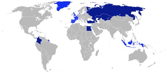
Afrikaans: Kaart van Transkontinentale nasies.
state met 'n aangrensende grens
state met 'n nie-aangrensende grens
state met 'n gebied wat transkontinentale Dansk: Kort over transkontinentale nationer.
stater med en sammenhængende grænse.
stater med en ikke-sammenhængende grænse.
stater med et område, der er transkontinentale. English: Map of transcontinental nations.
states with a contiguous boundary.
states with a non-contiguous boundary.
states with a territory that's transcontinental. Español: Mapa de las naciones transcontinental.
estados con un límite contigua.
estados con un límite no contigua.
Estados con un área de Transcontinental. Français : Carte des pays transcontinentaux.
pays ayant une continuité territoriale de ses frontières.
pays sans continuité territoriale de ses frontières.
pays ayant un territoire transcontinental. Nederlands: Kaart van Transcontinentale naties.
staten met een aangrenzende grens.
staten met een niet-aangrenzende grens.
staten met een gebied dat transcontinentaal is. Türkçe: Kıtalararası Ülkeler.
Bitişik sınır ülkeleri.
Sınırı bitişik olmayan ülkeler.
Denizaşırı toprağı bulunan ülkeler. Русский: Карта Трансконтинентальных стран.
Государства с примыкающей границей.
Государства с несмежной границей.
Государства с Трансконтинентальной площадью. العربية : خريطة الدول عابرة للقارات.
الدول التي لها حدود متماسك.
الدول التي لها حدود غير متجاورة.
الدول التي لديها أراضي هذا هو عابر للقارات. |
| تاريخ | |
| مصدر | عمل شخصى |
| مؤلف | $200inaire |
الترخيص
أنا، صاحب حقوق التأليف والنشر لهذا العمل، أنشر هذا العمل تحت الرخصة التالية:
الملف ده مترخص حسب رخصة المشاع الإبداعى نسبة المصنف للى مألفه - المشاركة بالمثل 3.0 العامه
- إنت حر:
- فى المشاركه – علشان نسخ و توزيع و بث العمل
- إنك تمزج – فى تكييف العمل
- بالشروط دى:
- نسبه ل – لازم يتنسب العمل للى مألفه بشكل مناسب و توفير رابط للرخصه وتحديد اذا حصلت تغييرات. ممكن ده يتعمل بأى طريقه معقوله، لكن مش بطريقه تشير ان مانح الرخصه بيوافقك على الاستعمال.
- مشاركه زي – لو عدت إنتاج المواد أو غيرت فيها، لازم تنشر مساهماتك اللى جايه من الأصل تحت ترخيص الأصل نفسه أو تحت ترخيص متوافق معاه.
تاريخ الفايل
اضغط على الساعه/التاريخ علشان تشوف الفايل زى ما كان فى الوقت ده.
| الساعه / التاريخ | صورة صغيرة | ابعاد | يوزر | تعليق | |
|---|---|---|---|---|---|
| دلوقتي | 19:41، 4 اغسطس 2014 | | 1,425 × 625 (40 كيلوبايت) | KronosLine | Added South Sudan, removed Kosovo (either include all breakaway regions or none) |
| 10:32، 5 ابريل 2014 |  | 1,425 × 625 (33 كيلوبايت) | SeeSchloss | Added French overseas territories (French Guyana, Southern territories, St Pierre & Miquelon, Guadeloupe, Martinique, Réunion, Mayotte, New Caledonia, Wallis & Futuna - I couldn't spot French Polynesia islands on the map) as well as Corsica. Added Spa... | |
| 04:09، 25 فبراير 2014 |  | 1,425 × 625 (40 كيلوبايت) | Scoelho86 | +POR | |
| 04:33، 31 يناير 2014 |  | 1,425 × 625 (40 كيلوبايت) | Scoelho86 | +COL | |
| 07:48، 13 يونيه 2012 |  | 1,425 × 625 (57 كيلوبايت) | $200inaire | Fix some errors and flaws in the map | |
| 23:16، 10 يونيه 2012 |  | 1,425 × 625 (56 كيلوبايت) | $200inaire |
استخدام الفايل
ال1 صفحة دى فيها وصله للفايل ده:
استخدام الملف العام
الويكيات التانيه دى بتستخدم الفايل ده:
- الاستخدام ف da.wikipedia.org
- الاستخدام ف la.wikipedia.org
- الاستخدام ف ml.wikipedia.org