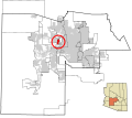
ملف:Maricopa County Incorporated and Planning areas El Mirage highlighted.svg

حجم معاينة PNG لذلك الملف ذي الامتداد SVG: 694 × 599 بكسل. الأبعاد التانيه: 278 × 240 بكسل | 556 × 480 بكسل | 889 × 768 بكسل | 1,185 × 1,024 بكسل | 2,371 × 2,048 بكسل | 940 × 812 بكسل.
الصوره الاصليه (ملف SVG، اساسا 940 × 812 بكسل، حجم الملف: 1.05 ميجابايت)
تاريخ الفايل
اضغط على الساعه/التاريخ علشان تشوف الفايل زى ما كان فى الوقت ده.
| الساعه / التاريخ | صورة صغيرة | ابعاد | يوزر | تعليق | |
|---|---|---|---|---|---|
| دلوقتي | 06:17، 20 مايو 2011 |  | 940 × 812 (1.05 ميجابايت) | Ixnayonthetimmay | Uploading new version |
| 04:03، 30 اغسطس 2008 |  | 900 × 800 (424 كيلوبايت) | Ixnayonthetimmay | == Summary == {{Information |Description=This map shows the incorporated areas and unincorporated areas in Maricopa County, Arizona. [[:en:El Mirage, Arizona | |
| 00:13، 16 سبتمبر 2007 |  | 900 × 800 (385 كيلوبايت) | Ixnayonthetimmay | ||
| 00:12، 16 سبتمبر 2007 |  | 900 × 800 (385 كيلوبايت) | Ixnayonthetimmay | {{Information |Description= |Source= |Date= |Author= |Permission= |other_versions= }} | |
| 09:53، 28 مايو 2007 |  | 900 × 780 (329 كيلوبايت) | Ixnayonthetimmay | ||
| 23:55، 21 مايو 2007 |  | 900 × 780 (318 كيلوبايت) | Ixnayonthetimmay | ||
| 04:58، 30 يناير 2007 |  | 904 × 758 (189 كيلوبايت) | Ixnayonthetimmay | {{Information |Description=This map shows the incorporated areas in Maricopa County, Arizona, highlighting El Mirage in red. It also shows the boundaries for th |
استخدام الفايل
ال1 صفحة دى فيها وصله للفايل ده:
استخدام الملف العام
الويكيات التانيه دى بتستخدم الفايل ده:
- الاستخدام ف ar.wikipedia.org
- الاستخدام ف ca.wikipedia.org
- الاستخدام ف ceb.wikipedia.org
- الاستخدام ف cy.wikipedia.org
- الاستخدام ف de.wikipedia.org
- الاستخدام ف eu.wikipedia.org
- الاستخدام ف fa.wikipedia.org
- الاستخدام ف fi.wikipedia.org
- الاستخدام ف fr.wikipedia.org
- الاستخدام ف glk.wikipedia.org
- الاستخدام ف ht.wikipedia.org
- الاستخدام ف hu.wikipedia.org
- الاستخدام ف it.wikipedia.org
- الاستخدام ف mzn.wikipedia.org
- الاستخدام ف pt.wikipedia.org
- الاستخدام ف sr.wikipedia.org
- الاستخدام ف tr.wikipedia.org
- الاستخدام ف tt.wikipedia.org
- الاستخدام ف www.wikidata.org
- الاستخدام ف zh-min-nan.wikipedia.org