ملف:Maricopa County Incorporated and Planning areas Scottsdale highlighted.svg

حجم معاينة PNG لذلك الملف ذي الامتداد SVG: 694 × 599 بكسل. الأبعاد التانيه: 278 × 240 بكسل | 556 × 480 بكسل | 889 × 768 بكسل | 1,185 × 1,024 بكسل | 2,371 × 2,048 بكسل | 940 × 812 بكسل.
الصوره الاصليه (ملف SVG، اساسا 940 × 812 بكسل، حجم الملف: 1.05 ميجابايت)
الخلاصة
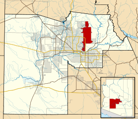
| وصف | This map shows the incorporated areas and Indian reservation boundaries in Maricopa County, Arizona, along with water bodies and major highways and roads. Scottsdale is highlighted in red. Other incorporated cities are shown in gray, planning area borders for these cities and Indian reservation borders are shown as solid black lines. Changes from Previous Version: Updated the maps to include water bodies and to make "less boring" than the plain black/white/gray maps. Format was updated to match standards laid out by WikiProject Maps/Conventions. Map data is based on data from the following Webpage: Maricopa County Interactive GIS Map. I created this map in Inkscape. |
| تاريخ | |
| مصدر | My own work, based on government information |
| مؤلف | Ixnayonthetimmay |
| سماح (إعادة استخدام الملف ده) |
Public Domain |
| إصدارات أخرى | See Category:Maps of Maricopa County for other versions of this image. |
الترخيص
| أنا، مالِك حقوق تأليف ونشر هذا العمل، أجعله في النِّطاق العامِّ، يسري هذا في أرجاء العالم كلِّه. في بعض البلدان، قد يكون هذا التَّرخيص غيرَ مُمكنٍ قانونيَّاً، في هذه الحالة: أمنح الجميع حق استخدام هذا العمل لأي غرض دون أي شرط ما لم يفرض القانون شروطًا إضافية. |
تاريخ الفايل
اضغط على الساعه/التاريخ علشان تشوف الفايل زى ما كان فى الوقت ده.
| الساعه / التاريخ | صورة صغيرة | ابعاد | يوزر | تعليق | |
|---|---|---|---|---|---|
| دلوقتي | 06:41، 20 مايو 2011 | | 940 × 812 (1.05 ميجابايت) | Ixnayonthetimmay | Uploading new version |
| 04:39، 30 اغسطس 2008 |  | 900 × 800 (413 كيلوبايت) | Ixnayonthetimmay | == Summary == {{Information |Description=This map shows the incorporated areas and unincorporated areas in Maricopa County, Arizona. [[:en:Paloma, Arizona|Pa | |
| 00:05، 16 سبتمبر 2007 |  | 900 × 800 (384 كيلوبايت) | Ixnayonthetimmay | {{Information |Description= |Source= |Date= |Author= |Permission= |other_versions= }} | |
| 10:13، 28 مايو 2007 |  | 900 × 780 (329 كيلوبايت) | Ixnayonthetimmay | ||
| 01:15، 22 مايو 2007 |  | 900 × 780 (318 كيلوبايت) | Ixnayonthetimmay | ||
| 05:24، 30 يناير 2007 |  | 904 × 758 (177 كيلوبايت) | Ixnayonthetimmay | {{Information |Description=This map shows the incorporated areas in Maricopa County, Arizona, highlighting Scottsdale in red. It also shows the boundaries for |
استخدام الفايل
ال1 صفحة دى فيها وصله للفايل ده:
استخدام الملف العام
الويكيات التانيه دى بتستخدم الفايل ده:
- الاستخدام ف ar.wikipedia.org
- الاستخدام ف br.wikipedia.org
- الاستخدام ف ca.wikipedia.org
- الاستخدام ف ceb.wikipedia.org
- الاستخدام ف de.wikipedia.org
- الاستخدام ف el.wikipedia.org
- الاستخدام ف eo.wikipedia.org
- الاستخدام ف eu.wikipedia.org
- الاستخدام ف fa.wikipedia.org
- الاستخدام ف fr.wikipedia.org
- الاستخدام ف ga.wikipedia.org
- الاستخدام ف gl.wikipedia.org
- الاستخدام ف ht.wikipedia.org
- الاستخدام ف hu.wikipedia.org
- الاستخدام ف id.wikipedia.org
- الاستخدام ف it.wikipedia.org
- الاستخدام ف ja.wikipedia.org
- الاستخدام ف kw.wikipedia.org
- الاستخدام ف mg.wikipedia.org
- الاستخدام ف ms.wikipedia.org
- الاستخدام ف pms.wikipedia.org
- الاستخدام ف ro.wikipedia.org
- الاستخدام ف sr.wikipedia.org
- الاستخدام ف sv.wikipedia.org
- الاستخدام ف sw.wikipedia.org
- الاستخدام ف tr.wikipedia.org
- الاستخدام ف tt.wikipedia.org
- الاستخدام ف ur.wikipedia.org
- الاستخدام ف vi.wikipedia.org
- الاستخدام ف vo.wikipedia.org
- الاستخدام ف www.wikidata.org
- الاستخدام ف zh.wikipedia.org