ملف:PIA23976-Mars-JezeroCraterMap-20200715.jpg

الصوره الاصليه (3,108 × 1,996 بكسل حجم الفايل: 834 كيلوبايت، نوع MIME: image/jpeg)
الخلاصة
| وصف |
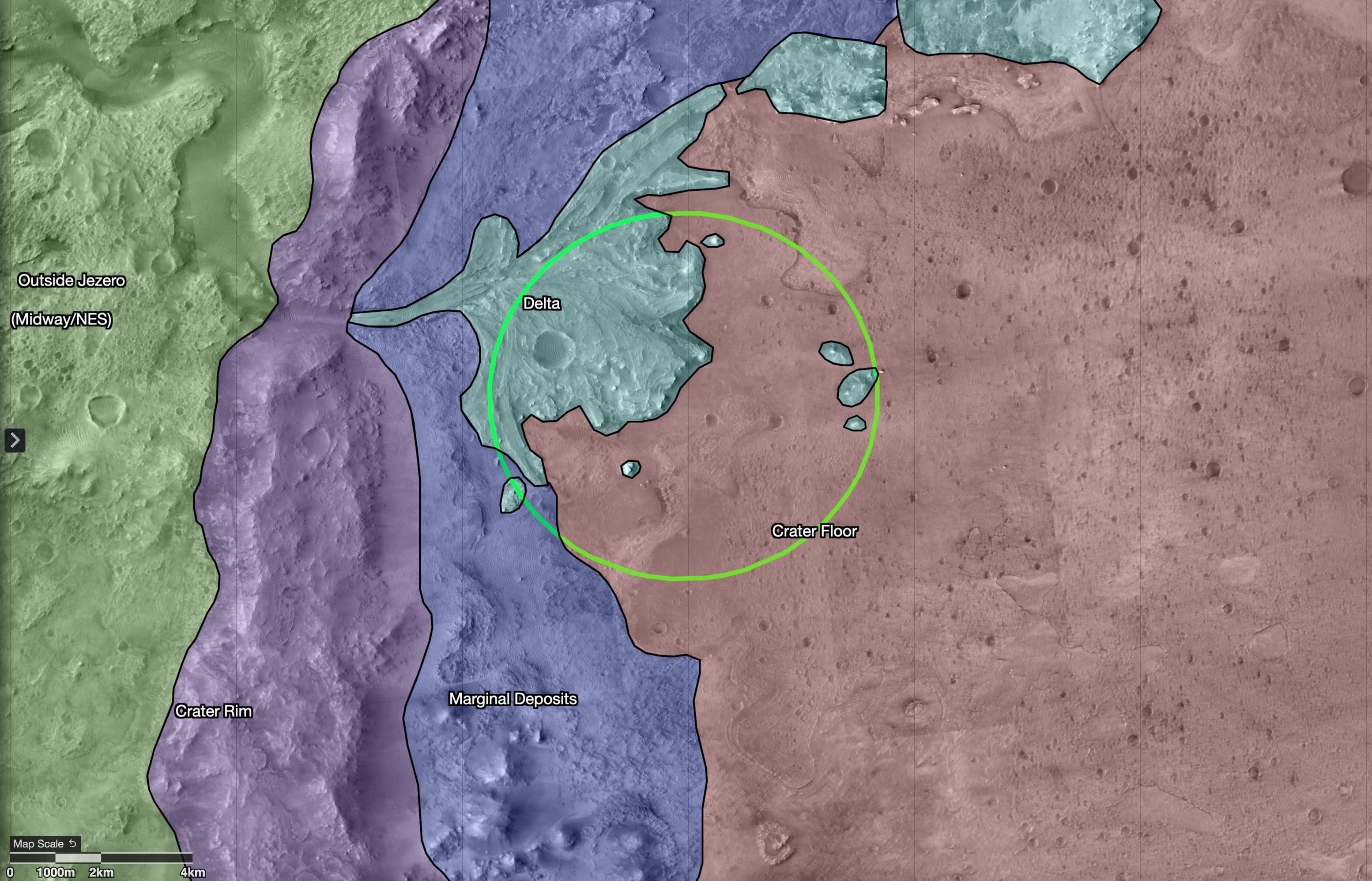
English: PIA23976: Map of Regions Around Mars' Jezero Crater
\https://photojournal.jpl.nasa.gov/catalog/PIA23976 This map shows regions in and around Jezero Crater on Mars, the landing site of NASA's Perseverance rover. The green circle represents the rover's landing ellipse. Jezero held a lake and river delta billions of years ago; scientists want to capture samples of rock in these regions that may contain evidence of ancient microscopic life, which will be returned to Earth by a future mission for extensive study. Each of these regions represents a distinct area that may hold different kinds of evidence. The outermost region, called Midway/Northeast Syrtis, could be considered for exploration after the rover's primary mission. The map was created in a tool called Campaign Analysis Mapping and Planning (CAMP), developed by NASA's Jet Propulsion Laboratory, a division of Caltech in Southern California, which manages the Mars 2020 Perseverance rover mission for NASA's Science Mission Directorate in Washington. Data for the map was provided by the High-Resolution Imaging Science Experiment (HiRISE), one of the cameras aboard NASA's Mars Reconnaissance Orbiter, also managed by JPL. The University of Arizona, in Tucson, operates HiRISE, which was built by Ball Aerospace & Technologies Corp., in Boulder, Colorado. |
| تاريخ | |
| مصدر | https://photojournal.jpl.nasa.gov/jpeg/PIA23976.jpg |
| مؤلف | NASA/JPL-Caltech/USGS/University of Arizona |
الترخيص
| يقع هذا العمل في النِّطاق العامّ في الولايات المُتحدة الأمريكيَّة لأَنَّه عملٌ خالِصٌ من إِنتاج وكالة الفضاء الأمريكيَّة. تنصُ حقوق التَّأليف والنَّشر الخاصَّة بوكالة الفضاء الأمريكيَّة على أنَّ "أعمال الوكالة غير مَحميَّة بحقوق التَّأليف والنَّشر ما لم يُذكر خلافُ ذلك". لمزيدٍ من المعلومات انظر القالِب {{PD-USGov}} وصفحة حقوق التَّأليف والنَّشر الخاصَّة بالوكالة وصفحة سياسة الصُّور الخاصَّة بمُختبر الدَّفع النَّفَّاث. | ||
 |
تنبيهات:
|
تاريخ الفايل
اضغط على الساعه/التاريخ علشان تشوف الفايل زى ما كان فى الوقت ده.
| الساعه / التاريخ | صورة صغيرة | ابعاد | يوزر | تعليق | |
|---|---|---|---|---|---|
| دلوقتي | 18:04، 17 يوليه 2020 | | 3,108 × 1,996 (834 كيلوبايت) | Drbogdan | Uploaded a work by NASA/JPL-Caltech/USGS/University of Arizona from https://photojournal.jpl.nasa.gov/jpeg/PIA23976.jpg with UploadWizard |
استخدام الفايل
ال1 صفحة دى فيها وصله للفايل ده:
استخدام الملف العام
الويكيات التانيه دى بتستخدم الفايل ده:
- الاستخدام ف ar.wikipedia.org
- الاستخدام ف eu.wikipedia.org
- الاستخدام ف fr.wikipedia.org
- الاستخدام ف he.wikipedia.org
- الاستخدام ف pl.wikipedia.org
- الاستخدام ف ro.wikipedia.org
- الاستخدام ف ru.wikipedia.org
- الاستخدام ف sv.wikipedia.org