ملف:Platanus occidentalis map.png
حجم البروفه دى: 564 × 599 بكسل. البعدان التانيين: 226 × 240 بكسل | 636 × 676 بكسل.
الصوره الاصليه (636 × 676 بكسل حجم الفايل: 123 كيلوبايت، نوع MIME: image/png)
الخلاصة
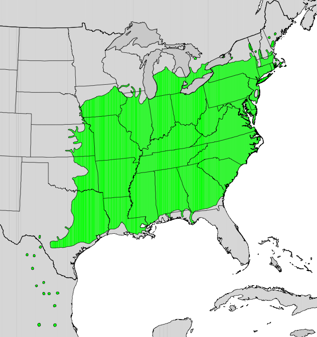
| وصف |
English: Range map of Platanus occidentalis |
| تاريخ | |
| مصدر | Digital representation of "Atlas of United States Trees" by Elbert L. Little, Jr. [1] |
| مؤلف | U.S. Geological Survey |
الترخيص
تقع هذه الصُّورة في النِّطاق العامّ لأنَّها تحتوي مواد حصريَّة مِن إِنتاج هيئة المساحة الجيولوجيَّة الأمريكيَّة في وزارة الداخلية في الولايات المُتحدة الأمريكيَّة. للمزيد مِن المعلومات انظر سياسية حقوق التَّأليف والنَّشر في موقع هيئة المساحة الجيولوجيَّة الأمريكيَّة الرسميَّة.
|
سجلُّ الرَّفع الأصيل
The original description page was here. All following user names refer to en.wikipedia.
- 2010-05-13 16:32 Masebrock 636×676× (125749 bytes) {{Information |Description=Range map of Platanus occidentalis |Source=Digital representation of "Atlas of United States Trees" by Elbert L. Little, Jr. [http://esp.cr.usgs.gov/data/atlas/little/] |Date=1999 |Author=U.S. Geological Survey |Permission={{PD-
تاريخ الفايل
اضغط على الساعه/التاريخ علشان تشوف الفايل زى ما كان فى الوقت ده.
| الساعه / التاريخ | صورة صغيرة | ابعاد | يوزر | تعليق | |
|---|---|---|---|---|---|
| دلوقتي | 05:22، 17 يناير 2011 | | 636 × 676 (123 كيلوبايت) | GreenZmiy | {{Information |Description={{en|Range map of Platanus occidentalis}} |Source=Transferred from [http://en.wikipedia.org en.wikipedia]<br/> (Original text : ''Digital representation of "Atlas of United States Trees" by Elbert L. Little, Jr. [http://esp.cr.u |
استخدام الفايل
ال1 صفحة دى فيها وصله للفايل ده:
استخدام الملف العام
الويكيات التانيه دى بتستخدم الفايل ده:
- الاستخدام ف ar.wikipedia.org
- الاستخدام ف bg.wikipedia.org
- الاستخدام ف ca.wikipedia.org
- الاستخدام ف ceb.wikipedia.org
- الاستخدام ف cs.wikipedia.org
- الاستخدام ف en.wikipedia.org
- الاستخدام ف et.wikipedia.org
- الاستخدام ف eu.wikipedia.org
- الاستخدام ف fa.wikipedia.org
- الاستخدام ف fr.wikipedia.org
- الاستخدام ف hr.wikipedia.org
- الاستخدام ف hu.wikipedia.org
- الاستخدام ف it.wikipedia.org
- الاستخدام ف ja.wikipedia.org
- الاستخدام ف no.wikipedia.org
- الاستخدام ف pl.wikipedia.org
- الاستخدام ف ro.wikipedia.org
- الاستخدام ف ru.wikipedia.org
- الاستخدام ف sk.wikipedia.org
- الاستخدام ف sv.wikipedia.org
- الاستخدام ف tr.wikipedia.org
- الاستخدام ف www.wikidata.org
- الاستخدام ف zh.wikipedia.org