ملف:Possible definitions of the boundary between Europe and Asia.png
الصوره الاصليه (729 × 1,129 بكسل حجم الفايل: 207 كيلوبايت، نوع MIME: image/png)
الخلاصة
| وصف |
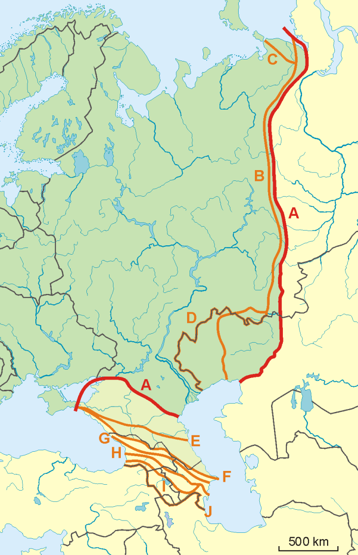
English: A map of possible definitions of the boundary between Asia and Europe.
Note that most of these lines are not referenced to any sources proposing them. The red line marked "A" is apparently the "Strahlenberg" definition commononly taught in Soviet-era Russia. See File:Historical Europe-Asia boundaries 1700 to 1900.png for a map which is actually based on references. The modern mainstream definition used by the UN (see also this) are marked "B" (Urals and Ural River) and "F" (Caucasus watershed). Lines C, D, E, G, H, I and J are currently without reference. Red line - "Strahlenberg" border, allegedly also used by the International Geographical Union [1]
Orange lines - other variants of border:
Polski: Mapa wariantów przebiegów granicy pomiędzy Europą a Azją
linie pomarańczowe - inne warianty przebiegu granicy:
|
| تاريخ | 09-04-2008 |
| مصدر | عمل شخصى |
| مؤلف | Aotearoa |
| إصدارات أخرى | Image:TransAsia m.png, File:Historical Europe-Asia boundaries 1700 to 1900.png |
الترخيص

|
يسمح بنسخ و توزيع و / أو تعديل الوثيقه دى تحت شروط رخصة جنو للوثائق الحره، الإصدار 1.2 أو أى إصدار تنشره مؤسسة البرمجيات الحره؛ بدون أقسام ثابته و بدون نصوص أغلفه أماميه و بدون نصوص أغلفه خلفيه. نسخه من الرخصه متضمنه ف قسم اسمه GNU Free Documentation License. |
- إنت حر:
- فى المشاركه – علشان نسخ و توزيع و بث العمل
- إنك تمزج – فى تكييف العمل
- بالشروط دى:
- نسبه ل – لازم يتنسب العمل للى مألفه بشكل مناسب و توفير رابط للرخصه وتحديد اذا حصلت تغييرات. ممكن ده يتعمل بأى طريقه معقوله، لكن مش بطريقه تشير ان مانح الرخصه بيوافقك على الاستعمال.
- مشاركه زي – لو عدت إنتاج المواد أو غيرت فيها، لازم تنشر مساهماتك اللى جايه من الأصل تحت ترخيص الأصل نفسه أو تحت ترخيص متوافق معاه.
تاريخ الفايل
اضغط على الساعه/التاريخ علشان تشوف الفايل زى ما كان فى الوقت ده.
| الساعه / التاريخ | صورة صغيرة | ابعاد | يوزر | تعليق | |
|---|---|---|---|---|---|
| دلوقتي | 08:34، 14 نوفمبر 2022 | | 729 × 1,129 (207 كيلوبايت) | Рагин1987 | Dull shade of green up to the "F" line |
| 13:12، 19 فبراير 2022 |  | 729 × 1,129 (205 كيلوبايت) | Lojwe | Frame removed | |
| 20:29، 1 اكتوبر 2010 |  | 735 × 1,134 (156 كيلوبايت) | Bogomolov.PL | Reverted to version as of 08:57, 9 April 2008 | |
| 19:44، 1 اكتوبر 2010 |  | 735 × 1,134 (137 كيلوبايت) | Zé Carioca~commonswiki | Trying to fix the error we are facing on the articles. | |
| 15:56، 1 اكتوبر 2010 |  | 735 × 1,134 (137 كيلوبايت) | Gvogas | Inclusion of the Miles Clark route line. (sorry for the tries, my internet gave problems). | |
| 15:55، 1 اكتوبر 2010 |  | 735 × 1,134 (137 كيلوبايت) | Gvogas | Reverted to version as of 15:52, 1 October 2010 | |
| 15:54، 1 اكتوبر 2010 |  | 735 × 1,134 (137 كيلوبايت) | Gvogas | (Inclusion of the Miles Clark route line.) | |
| 15:52، 1 اكتوبر 2010 |  | 735 × 1,134 (137 كيلوبايت) | Gvogas | Inclusion of the Miles Clark route line. | |
| 08:57، 9 ابريل 2008 |  | 735 × 1,134 (156 كيلوبايت) | Aotearoa | {{Information |Description=Map of Europe (green) - Asia (yellow) border. Red line (A) - border accoring to International Geographical Union and most European geographers, orange lines - other variants of border. |Source=własna praca |Date=09-04-2008 | |
استخدام الفايل
ال1 صفحة دى فيها وصله للفايل ده:
استخدام الملف العام
الويكيات التانيه دى بتستخدم الفايل ده:
- الاستخدام ف am.wikipedia.org
- الاستخدام ف ar.wikipedia.org
- الاستخدام ف az.wikipedia.org
- الاستخدام ف ba.wikipedia.org
- الاستخدام ف be.wikipedia.org
- الاستخدام ف bn.wikipedia.org
- الاستخدام ف ca.wikipedia.org
- الاستخدام ف ce.wikipedia.org
- الاستخدام ف cs.wikipedia.org
- الاستخدام ف de.wikipedia.org
- Eurasien
- Portal:Mauern und Grenzen
- Liste interkontinentaler Staaten
- Wikipedia Diskussion:WikiProjekt Geographie/Archiv/2013-1
- Wikipedia:Löschkandidaten/28. Februar 2016
- Wikipedia Diskussion:WikiProjekt Kategorien/Archiv/2016-II
- Wikipedia Diskussion:Kurier/Archiv/2017/10
- Vorlage Diskussion:Navigationsleiste Kraftwerke
- Wikipedia Diskussion:Kurier/Archiv/2022/08
- الاستخدام ف en.wikipedia.org
- الاستخدام ف et.wikipedia.org
- الاستخدام ف hr.wikipedia.org
- Kategorija:Arktičkooceanski slijev (Europa)
- Kategorija:Arktičkooceanski slijev (Azija)
- Kategorija:Mora Arktičkog oceana
- Kategorija:Reljefni oblici u Arktičkom oceanu
- Kategorija:Mora Arktičkog oceana (Azija)
- Kategorija:Mora Arktičkog oceana (Europa)
- Kategorija:Reljefni oblici u Arktičkom oceanu (Azija)
- Kategorija:Tjesnaci Arktičkog oceana (Europa)
- Kategorija:Vodene mase Arktičkog oceana (Europa)
- Kategorija:Reljefni oblici u Arktičkom oceanu (Europa)
- Kategorija:Tjesnaci Arktičkog oceana (Azija)
- Kategorija:Vodene mase Arktičkog oceana (Azija)
- Kategorija:Karsko more
- Predložak:Granica Europe i Azije
- Kategorija:Zaljevi Arktičkog oceana (Azija)
- Kategorija:Zaljevi Arktičkog oceana (Europa)
- Kategorija:Estuariji Arktičkog oceana (Azija)
- Kategorija:Estuariji Tihog oceana (Azija)
- الاستخدام ف hu.wikipedia.org
- الاستخدام ف hy.wikipedia.org
- الاستخدام ف ia.wikipedia.org
اعرض استخدام عام اكتر للملف ده.