ملف:Prefecture map of Crete (Greece).svg

حجم معاينة PNG لذلك الملف ذي الامتداد SVG: 693 × 599 بكسل. الأبعاد التانيه: 278 × 240 بكسل | 555 × 480 بكسل | 888 × 768 بكسل | 1,184 × 1,024 بكسل | 2,369 × 2,048 بكسل | 8,460 × 7,315 بكسل.
الصوره الاصليه (ملف SVG، اساسا 8,460 × 7,315 بكسل، حجم الملف: 1.82 ميجابايت)
.svg)
الخلاصة
| وصف |
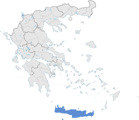
English: The prefecture of Crete within Greece. |
| تاريخ | |
| مصدر | عمل شخصى |
| مؤلف | SilentResident,Philly boy92 |
الترخيص
أنا، صاحب حقوق التأليف والنشر لهذا العمل، أنشر هذا العمل تحت الرخصة التالية:
الملف ده مترخص حسب رخصة المشاع الإبداعى نسبة المصنف للى مألفه - المشاركة بالمثل 3.0 العامه
- إنت حر:
- فى المشاركه – علشان نسخ و توزيع و بث العمل
- إنك تمزج – فى تكييف العمل
- بالشروط دى:
- نسبه ل – لازم يتنسب العمل للى مألفه بشكل مناسب و توفير رابط للرخصه وتحديد اذا حصلت تغييرات. ممكن ده يتعمل بأى طريقه معقوله، لكن مش بطريقه تشير ان مانح الرخصه بيوافقك على الاستعمال.
- مشاركه زي – لو عدت إنتاج المواد أو غيرت فيها، لازم تنشر مساهماتك اللى جايه من الأصل تحت ترخيص الأصل نفسه أو تحت ترخيص متوافق معاه.
تاريخ الفايل
اضغط على الساعه/التاريخ علشان تشوف الفايل زى ما كان فى الوقت ده.
| الساعه / التاريخ | صورة صغيرة | ابعاد | يوزر | تعليق | |
|---|---|---|---|---|---|
| دلوقتي | 18:00، 17 يناير 2015 | | 8,460 × 7,315 (1.82 ميجابايت) | SilentResident | The Map has been updated to include some missing territories of Greece; fixed outline and color differences for some Greek islands in the Ionian and Aegean Seas that could confuse the readers. |
| 22:34، 16 يناير 2015 |  | 7,304 × 7,315 (1.74 ميجابايت) | SilentResident | {{Information |Description ={{en|1=The prefecture of Crete within Greece.}} |Source ={{own}} |Author =SilentResident,Philly boy92 |Date =2014-01-16 |Permission = |other_vers... |
استخدام الفايل
مافيش صفحات بتوصل للفايل ده.
استخدام الملف العام
الويكيات التانيه دى بتستخدم الفايل ده:
- الاستخدام ف ar.wikipedia.org
- الاستخدام ف ast.wikipedia.org
- الاستخدام ف ca.wikipedia.org
- الاستخدام ف diq.wikipedia.org
- الاستخدام ف el.wikipedia.org
- الاستخدام ف en.wikipedia.org
- الاستخدام ف en.wikivoyage.org
- الاستخدام ف eu.wikipedia.org
- الاستخدام ف fi.wiktionary.org
- الاستخدام ف ga.wikipedia.org
- الاستخدام ف gl.wikipedia.org
- الاستخدام ف ha.wikipedia.org
- الاستخدام ف hy.wikipedia.org
- الاستخدام ف hyw.wikipedia.org
- الاستخدام ف ia.wikipedia.org
- الاستخدام ف la.wikipedia.org
- الاستخدام ف lb.wikipedia.org
- الاستخدام ف mzn.wikipedia.org
- الاستخدام ف tr.wikipedia.org
- الاستخدام ف tt.wikipedia.org
- الاستخدام ف www.wikidata.org
.svg)