ملف:Remains of former canal bridge, Wrockwardine Wood - geograph.org.uk - 1352074.jpg
مافيش ريزوليوشن اعلى متوفر.
Remains_of_former_canal_bridge,_Wrockwardine_Wood_-_geograph.org.uk_-_1352074.jpg (640 × 451 بكسل حجم الفايل: 93 كيلوبايت، نوع MIME: image/jpeg)
الخلاصة
| وصف |
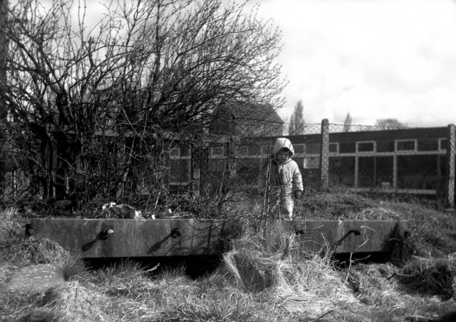
English: Remains of former canal bridge, Wrockwardine Wood The child here is standing on the deck of a former canal bridge. The canal has been filled in, although had I got here about five years earlier it would probably have still been in water. This was the Wombridge Canal, opened in 1788, which extended westwards from the previously isolated Donnington Wood Canal to Wombridge, and later about 1795 was connected by the Trench Inclined Plane to the Shrewsbury Canal at Trench Lock. The canal here was used by tub boats, measuring about 20ft x 6ft, and with capacity for about 8 tons of coal. The main traffic was coal, westwards from the collieries at Donnington Wood to Shrewsbury. At Trench Lock, the cargo was transferred from the tub boats into special 'narrow' narrowboats for onward shipment to Shrewsbury. Unfortunately the zombies of the Telford New Town development agency ignored all the rich industrial heritage in this area, and it has now all disappeared submerged in a sea of mediocrity. |
| تاريخ | |
| مصدر | From geograph.org.uk |
| مؤلف | Dr Neil Clifton |
| نسبه ل (required by the license) | Dr Neil Clifton / Remains of former canal bridge, Wrockwardine Wood / |
| موقع الكاميرا | | هذه وغيرها من الصور في مواقعها على: خريطة الشارع المفتوحة |
|---|
_heading:0.00&language=arz)
| موقع الكائن | | هذه وغيرها من الصور في مواقعها على: خريطة الشارع المفتوحة |
|---|
_heading:0.00&language=arz)
الترخيص

|
هذه الصُّورة مَأخُوذةٌ مِن مَجمُوعة مَشروع الجغرافيا. انظر صفحة هذه الصُّورة في موقع المَشروع للحصول على تفاصيل التَّواصل مع المُصوِّر. يَملك Dr Neil Clifton حقوق التَّأليف والنَّشر لهذه الصُّورة، وهي مَنشُورة تحت رُخصة المشاع الإِبداعيِّ المُلزِمة بنسبة العمل إلى مؤلفه وبالمشاركة تحت الرُّخصة نفسها.
|
هذا الملف مُرخص تحت رخصة المشاع المبدع نسبة المصنف إلى مؤلفه - المشاركة على قدم المساواة 2.0 العامة
نسبه ل: Dr Neil Clifton
- إنت حر:
- فى المشاركه – علشان نسخ و توزيع و بث العمل
- إنك تمزج – فى تكييف العمل
- بالشروط دى:
- نسبه ل – لازم يتنسب العمل للى مألفه بشكل مناسب و توفير رابط للرخصه وتحديد اذا حصلت تغييرات. ممكن ده يتعمل بأى طريقه معقوله، لكن مش بطريقه تشير ان مانح الرخصه بيوافقك على الاستعمال.
- مشاركه زي – لو عدت إنتاج المواد أو غيرت فيها، لازم تنشر مساهماتك اللى جايه من الأصل تحت ترخيص الأصل نفسه أو تحت ترخيص متوافق معاه.
تاريخ الفايل
اضغط على الساعه/التاريخ علشان تشوف الفايل زى ما كان فى الوقت ده.
| الساعه / التاريخ | صورة صغيرة | ابعاد | يوزر | تعليق | |
|---|---|---|---|---|---|
| دلوقتي | 08:38، 28 فبراير 2011 | | 640 × 451 (93 كيلوبايت) | GeographBot | == {{int:filedesc}} == {{Information |description={{en|1=Remains of former canal bridge, Wrockwardine Wood The child here is standing on the deck of a former canal bridge. The canal has been filled in, although had I got here about five years earlier it |
استخدام الفايل
ال2 صفحة دى فيها وصله للفايل ده:
استخدام الملف العام
الويكيات التانيه دى بتستخدم الفايل ده:
- الاستخدام ف en.wikipedia.org
- الاستخدام ف www.wikidata.org