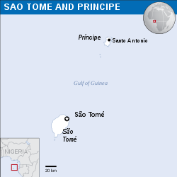
ملف:São Tomé and Príncipe - Location Map (2013) - STP - UNOCHA.svg

حجم معاينة PNG لذلك الملف ذي الامتداد SVG: 250 × 250 بكسل. الأبعاد التانيه: 240 × 240 بكسل | 480 × 480 بكسل | 768 × 768 بكسل | 1,024 × 1,024 بكسل | 2,048 × 2,048 بكسل.
الصوره الاصليه (ملف SVG، اساسا 250 × 250 بكسل، حجم الملف: 348 كيلوبايت)
تاريخ الفايل
اضغط على الساعه/التاريخ علشان تشوف الفايل زى ما كان فى الوقت ده.
| الساعه / التاريخ | صورة صغيرة | ابعاد | يوزر | تعليق | |
|---|---|---|---|---|---|
| دلوقتي | 06:09، 10 سبتمبر 2016 |  | 250 × 250 (348 كيلوبايت) | Wereldburger758 | Resized page to drawing. Removal watermark. Validation of image. |
| 01:14، 8 مايو 2014 |  | 254 × 254 (372 كيلوبايت) | UN OCHA maps bot | == {{int:filedesc}} == {{Information |description={{en|1=Locator map of São Tomé and Príncipe.}} |date=2013 |source={{en|1=[http://reliefweb.int/map/sao-tome-and-principe/sao-tome-and-principe-location-map-2013 Sao... |
استخدام الفايل
ال1 صفحة دى فيها وصله للفايل ده:
استخدام الملف العام
الويكيات التانيه دى بتستخدم الفايل ده:
- الاستخدام ف ar.wikipedia.org
- الاستخدام ف ast.wikipedia.org
- الاستخدام ف ca.wikipedia.org
- الاستخدام ف ceb.wikipedia.org
- الاستخدام ف ee.wikipedia.org
- الاستخدام ف el.wikipedia.org
- الاستخدام ف en.wikipedia.org
- الاستخدام ف eo.wikipedia.org
- الاستخدام ف es.wikipedia.org
- الاستخدام ف eu.wikipedia.org
- الاستخدام ف ga.wikipedia.org
- الاستخدام ف gl.wikipedia.org
- الاستخدام ف ha.wikipedia.org
- الاستخدام ف ht.wikipedia.org
- الاستخدام ف hu.wikipedia.org
- الاستخدام ف ia.wikipedia.org
- الاستخدام ف id.wikipedia.org
- الاستخدام ف kab.wikipedia.org
- الاستخدام ف la.wikipedia.org
- الاستخدام ف mdf.wikipedia.org
- الاستخدام ف mzn.wikipedia.org
- الاستخدام ف pl.wikipedia.org
- الاستخدام ف pt.wikipedia.org
- الاستخدام ف sd.wikipedia.org
- الاستخدام ف szl.wikipedia.org
- الاستخدام ف te.wikipedia.org
- الاستخدام ف tt.wikipedia.org
- الاستخدام ف uk.wikipedia.org
- الاستخدام ف vi.wikipedia.org
- الاستخدام ف www.wikidata.org
- الاستخدام ف zh-yue.wikipedia.org
