ملف:South Yorkshire UK locator map 2010.svg

حجم معاينة PNG لذلك الملف ذي الامتداد SVG: 494 × 600 بكسل. الأبعاد التانيه: 198 × 240 بكسل | 395 × 480 بكسل | 633 × 768 بكسل | 843 × 1,024 بكسل | 1,687 × 2,048 بكسل | 1,108 × 1,345 بكسل.
الصوره الاصليه (ملف SVG، اساسا 1,108 × 1,345 بكسل، حجم الملف: 302 كيلوبايت)
الخلاصة
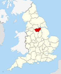
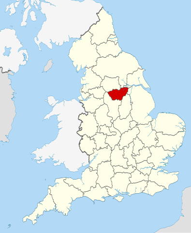
| وصف | Location of the ceremonial county of South Yorkshire within England. |
| تاريخ | |
| مصدر |
National Geospatial-Intelligence Agency
|
| مؤلف | Nilfanion |
الترخيص
أنا، صاحب حقوق التأليف والنشر لهذا العمل، أنشر هذا العمل تحت الرخص التالية:
الملف ده مترخص حسب رخصة المشاع الإبداعى نسبة المصنف للى مألفه - المشاركة بالمثل 3.0 العامه
- إنت حر:
- فى المشاركه – علشان نسخ و توزيع و بث العمل
- إنك تمزج – فى تكييف العمل
- بالشروط دى:
- نسبه ل – لازم يتنسب العمل للى مألفه بشكل مناسب و توفير رابط للرخصه وتحديد اذا حصلت تغييرات. ممكن ده يتعمل بأى طريقه معقوله، لكن مش بطريقه تشير ان مانح الرخصه بيوافقك على الاستعمال.
- مشاركه زي – لو عدت إنتاج المواد أو غيرت فيها، لازم تنشر مساهماتك اللى جايه من الأصل تحت ترخيص الأصل نفسه أو تحت ترخيص متوافق معاه.

|
يسمح بنسخ و توزيع و / أو تعديل الوثيقه دى تحت شروط رخصة جنو للوثائق الحره، الإصدار 1.2 أو أى إصدار تنشره مؤسسة البرمجيات الحره؛ بدون أقسام ثابته و بدون نصوص أغلفه أماميه و بدون نصوص أغلفه خلفيه. نسخه من الرخصه متضمنه ف قسم اسمه GNU Free Documentation License. |
اختار الرخصه اللى تناسبك.

|
This is one of the images forming part of the Valued image set: Locator maps of the Ceremonial counties of England on Wikimedia Commons. The image set has been assessed under the valued image set criteria and is considered the most valued set on Commons within the scope:
Locator maps of the Ceremonial counties of England
You can see its nomination at Commons:Valued image candidates/Locator maps of English ceremonial counties. |
تاريخ الفايل
اضغط على الساعه/التاريخ علشان تشوف الفايل زى ما كان فى الوقت ده.
| الساعه / التاريخ | صورة صغيرة | ابعاد | يوزر | تعليق | |
|---|---|---|---|---|---|
| دلوقتي | 22:44، 23 نوفمبر 2010 | | 1,108 × 1,345 (302 كيلوبايت) | Nilfanion | == Summary == {{Information |Description=Location of the ceremonial county of South Yorkshire within England. |Source=Ordnance Survey [https://www.ordnancesurvey.co.uk/opendatadownload/products.html OpenData]: * |
استخدام الفايل
ال1 صفحة دى فيها وصله للفايل ده:
استخدام الملف العام
الويكيات التانيه دى بتستخدم الفايل ده:
- الاستخدام ف af.wikipedia.org
- الاستخدام ف an.wikipedia.org
- الاستخدام ف ast.wikipedia.org
- الاستخدام ف be-tarask.wikipedia.org
- الاستخدام ف bg.wikipedia.org
- الاستخدام ف bn.wikipedia.org
- الاستخدام ف ca.wikipedia.org
- الاستخدام ف ceb.wikipedia.org
- الاستخدام ف cs.wikipedia.org
- الاستخدام ف dag.wikipedia.org
- الاستخدام ف en.wikipedia.org
- South Yorkshire
- Five Weirs Walk
- Attercliffe Chapel
- Kendray
- Gildingwells
- Moorends
- Clayton, South Yorkshire
- Great Houghton, South Yorkshire
- Staincross
- Mapplewell
- Cubley, South Yorkshire
- Barugh, South Yorkshire
- Barugh Green
- Ingbirchworth
- Jump, South Yorkshire
- Gawber
- Little Houghton, South Yorkshire
- Silkstone Common
- Stairfoot
- Gilroyd
- Wilthorpe
- New Lodge, South Yorkshire
- Wharncliffe Side
- Richmond, Sheffield
- Ranmoor
- Graves Park (ward)
- Belle Vue, South Yorkshire
- Shiregreen and Brightside
- Deepcar
- East Ecclesfield
- West Ecclesfield
- Fenwick, South Yorkshire
- Thorpe Hesley
- Brodsworth Colliery
- Parkgate, South Yorkshire
- Highfields, South Yorkshire
- Rother Valley Country Park
- Hemingfield
اعرض استخدام عام اكتر للملف ده.