ملف:West Bank Access Restrictions June 2020.pdf

الصوره الاصليه (4,964 × 7,020 بكسل حجم الفايل: 15.18 ميجابايت، نوع MIME: application/pdf)
الخلاصة
| وصف |
English: West Bank access restrictions map |
| تاريخ | |
| مصدر | https://www.ochaopt.org/sites/default/files/westbank_a0_25_06_2020_final.pdf |
| مؤلف | United Nations OCHA oPt |
الترخيص
| This image is a map derived from a United Nations map.
Unless stated otherwise, UN maps are to be considered in the public domain. This applies worldwide. UN maps are, in principle, open source material and you can use them in your work or for making your own map. UN requests however that you delete the UN name, logo and reference number upon any modification to the map. Content of your map will be your responsibility. You can state in your publication, if you wish, something like: based on UN map … (map name, map number, revision number and date). See: Geospatial Information Section. And: Geospatial, location data for a better world. |
 |
تاريخ الفايل
اضغط على الساعه/التاريخ علشان تشوف الفايل زى ما كان فى الوقت ده.
| الساعه / التاريخ | صورة صغيرة | ابعاد | يوزر | تعليق | |
|---|---|---|---|---|---|
| دلوقتي | 13:53، 20 مايو 2021 | 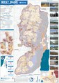 | 4,964 × 7,020 (15.18 ميجابايت) | Jul059 | Lossless file size reduction |
| 20:33، 14 ديسمبر 2020 | لا تصغير | 0 × 0 (15.92 ميجابايت) | Veggies | Updated for 2020 | |
| 17:32، 27 يناير 2016 | لا تصغير | 0 × 0 (17.08 ميجابايت) | Triggerhippie4 | User created page with UploadWizard |
استخدام الفايل
ال1 صفحة دى فيها وصله للفايل ده:
استخدام الملف العام
الويكيات التانيه دى بتستخدم الفايل ده:
- الاستخدام ف ar.wikipedia.org
- الاستخدام ف azb.wikipedia.org
- الاستخدام ف cs.wikipedia.org
- الاستخدام ف de.wikipedia.org
- الاستخدام ف de.wikivoyage.org
- الاستخدام ف el.wikipedia.org
- الاستخدام ف en.wikipedia.org
- Israeli settlement
- West Bank
- Population statistics for Israeli settlements in the West Bank
- Israeli checkpoint
- Settler colonialism
- Area C (West Bank)
- User:Falcaorib
- Palestinian enclaves
- Zionism as settler colonialism
- User:Carter McCrae/Israeli–Palestinian conflict
- Israeli incursions in the West Bank during the Israel–Hamas war
- الاستخدام ف en.wikivoyage.org
- الاستخدام ف eo.wikipedia.org
- الاستخدام ف eu.wikipedia.org
- الاستخدام ف fa.wikipedia.org
- الاستخدام ف fr.wikipedia.org
- الاستخدام ف fy.wikipedia.org
- الاستخدام ف ha.wikipedia.org
- الاستخدام ف he.wikipedia.org
- الاستخدام ف he.wikiquote.org
- الاستخدام ف id.wikipedia.org
- الاستخدام ف it.wikivoyage.org
- الاستخدام ف ja.wikipedia.org
- الاستخدام ف ka.wikipedia.org
- الاستخدام ف ko.wikipedia.org
- الاستخدام ف nl.wikipedia.org
- الاستخدام ف nl.wikinews.org
- الاستخدام ف pcm.wikipedia.org
- الاستخدام ف pl.wikipedia.org
- الاستخدام ف pt.wikipedia.org
- الاستخدام ف ru.wikipedia.org
اعرض استخدام عام اكتر للملف ده.